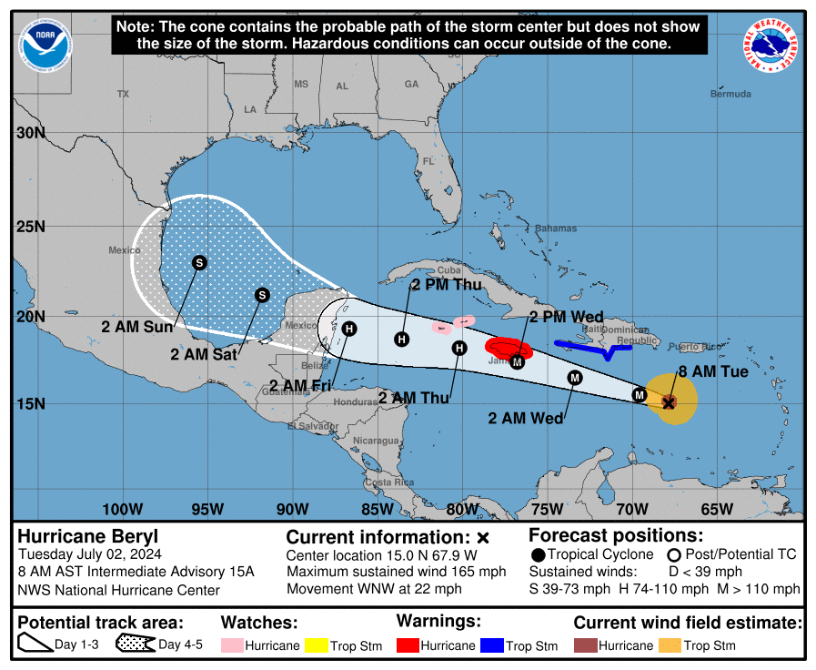
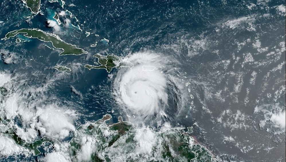
An 8 a.m. update from the National Hurricane Center on Tuesday noted that Hurricane Beryl has intensified and continues to move across the Caribbean, approximately 200 miles south of the USVI and Puerto Rico. Beryl is a dangerous Category 5 cyclone and is moving west-northwest at approximately 22 mph, with maximum sustained winds of about 165 mph.
As was reported in a previous Source update, Hurricane Beryl made landfall on Monday over Grenada’s Carriacou Island, and widespread damage has been reported across the region. The powerful cyclone, which has already broken historical weather records, is forecast to continue on a west-to-west-northwesterly track across the Caribbean.
“On the forecast track, the center of Beryl will move quickly across the southeastern and central Caribbean Sea today and is forecast to pass near Jamaica on Wednesday and the Cayman Islands on Thursday,” according to an update on Tuesday from the NHC.
Impacts Across USVI, Puerto Rico
No hurricane or tropical storm watches or warnings are in effect for the USVI or Puerto Rico. However, the National Weather Service in San Juan, Puerto Rico, explained that the local islands will experience several impacts from Beryl, including the potential for thunderstorms, gusty winds, and up to one or two inches of rain, with locally higher amounts. Flash flooding is possible.
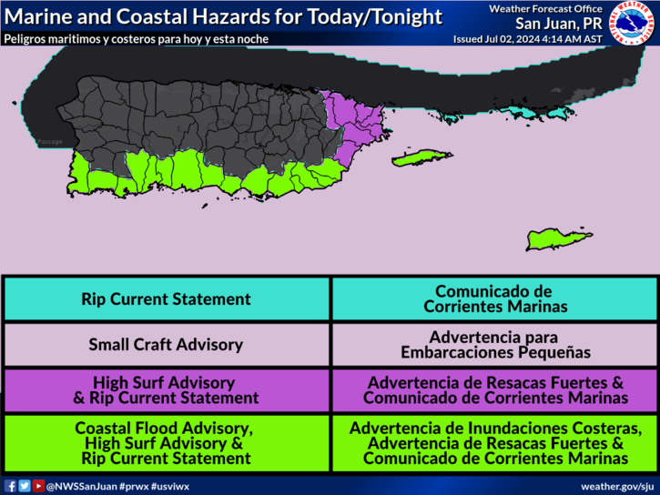
Most notably, marine conditions will be hazardous over the next couple of days, and several marine weather alerts are in effect for portions of both U.S. territories. A High Rip Current Risk, a High Surf Advisory, a Small Craft Advisory and a Coastal Flood Advisory are currently in effect. Wave heights are forecast to be impressive across the region and could reach up to 15 feet, particularly along some areas of the southern coastlines of Puerto Rico.
A press release from the Virgin Islands Port Authority on Tuesday provided information about some of the marine impacts across the local area.
“The Virgin Islands Port Authority announced that Royal Caribbean’s Icon of the Seas has canceled its scheduled call to the Austin ‘Babe’ Monsanto Marine Terminal in St. Thomas on Wednesday, July 3,” according to the VIPA update. “The cruise ship has changed its itinerary due to the inclement weather caused by Hurricane Beryl that is affecting the Windward and Eastern Caribbean islands,” the update continued.
“VIPA also alerts the public that rough seas may affect marine operations at the Wilfred ‘Bomba’ Allick Port and Transshipment Center (the Containerport) this week at Krause Lagoon in St. Croix,” it said.
The VIPA press release added that Cyril E. King Airport on St. Thomas and Henry E. Rohlsen Airport on St. Croix are open and operating on a regular schedule.
NHC Monitoring Additional Tropical Waves
The NHC continues to monitor a tropical wave behind Beryl, “Invest 96L.” While the chance of tropical development has decreased somewhat, the wave will be closely watched for potential impacts on the local islands starting around Thursday.
Following “Invest 96L,” another disturbance may bring inclement weather to the region at the beginning of next week.
Tropical Weather Updates
Weather forecast information, including severe weather alerts, is available from the VITEMA website and the National Weather Service. The Source Weather Page also publishes a daily weather forecast and offers readers the opportunity to view weather forecast videos and disaster preparedness video segments.
Finally, information regarding hurricane preparedness is available from the Virgin Islands Territorial Emergency Management Agency and the National Oceanic and Atmospheric Administration.


