The 2024 Atlantic Hurricane Season is expected to be very busy, according to a new report released on Thursday from Colorado State University’s (CSU) Tropical Meteorology Project.
“We anticipate that the 2024 Atlantic basin hurricane season will be extremely active,” the CSU report said. “Current El Niño conditions are likely to transition to La Niña conditions this summer/fall, leading to hurricane-favorable wind shear conditions. Sea surface temperatures in the eastern and central Atlantic are currently at record warm levels and are anticipated to remain well above-average for the upcoming hurricane season. A warmer-than-normal tropical Atlantic provides a more conducive dynamic and thermodynamic environment for hurricane formation and intensification,” the report explained.
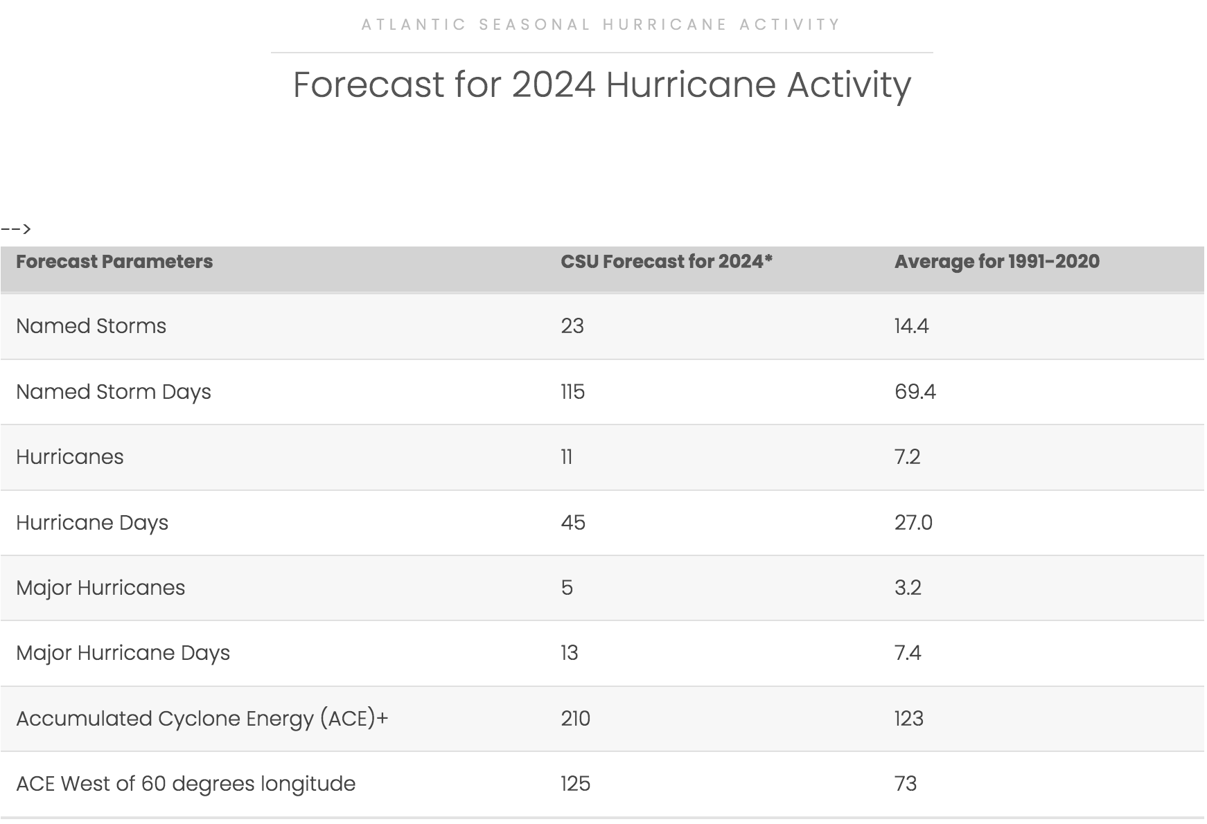
CSU expects a total of 23 named tropical cyclones during the season, with 11 storms developing into hurricanes and five storms strengthening into major hurricanes of Category 3 or higher.
“We estimate that 2024 will have 23 named storms (average is 14.4), 115 named storm days (average is 69.4), 11 hurricanes (average is 7.2), 45 hurricane days (average is 27.0), five major (Category 3-4-5) hurricanes (average is 3.2) and 13 major hurricane days (average is 7.4),” CSU stated. (CSU defines a hurricane day as “a measure of hurricane activity, one unit of which occurs as four six-hour periods during which a tropical cyclone is observed or is estimated to have hurricane-force wind.”)
The CSU forecast is the highest that CSU has ever released for a tropical outlook during April.
“All of our forecast model guidance is calling for a hyperactive season,” CSU said. “While there remains considerable uncertainty with any seasonal hurricane forecast issued in early April, the confidence in our prediction is higher than normal for an early April outlook.”
The seasonal outlook shared statistics, including a 66 percent chance that a major hurricane will pass through the Caribbean region. (The average chance of this occurring between 1880 and 2020 was 47 percent.)
The report stressed that, although the season is anticipated to be busy, individuals should always be prepared for severe weather.
“Coastal residents are reminded that it only takes one hurricane making landfall to make it an active season for them,” the update cautioned. “Thorough preparations should be made for every season, regardless of how much activity is predicted,” CSU recommended.
Ingredients Contributing to a Potentially Active Season
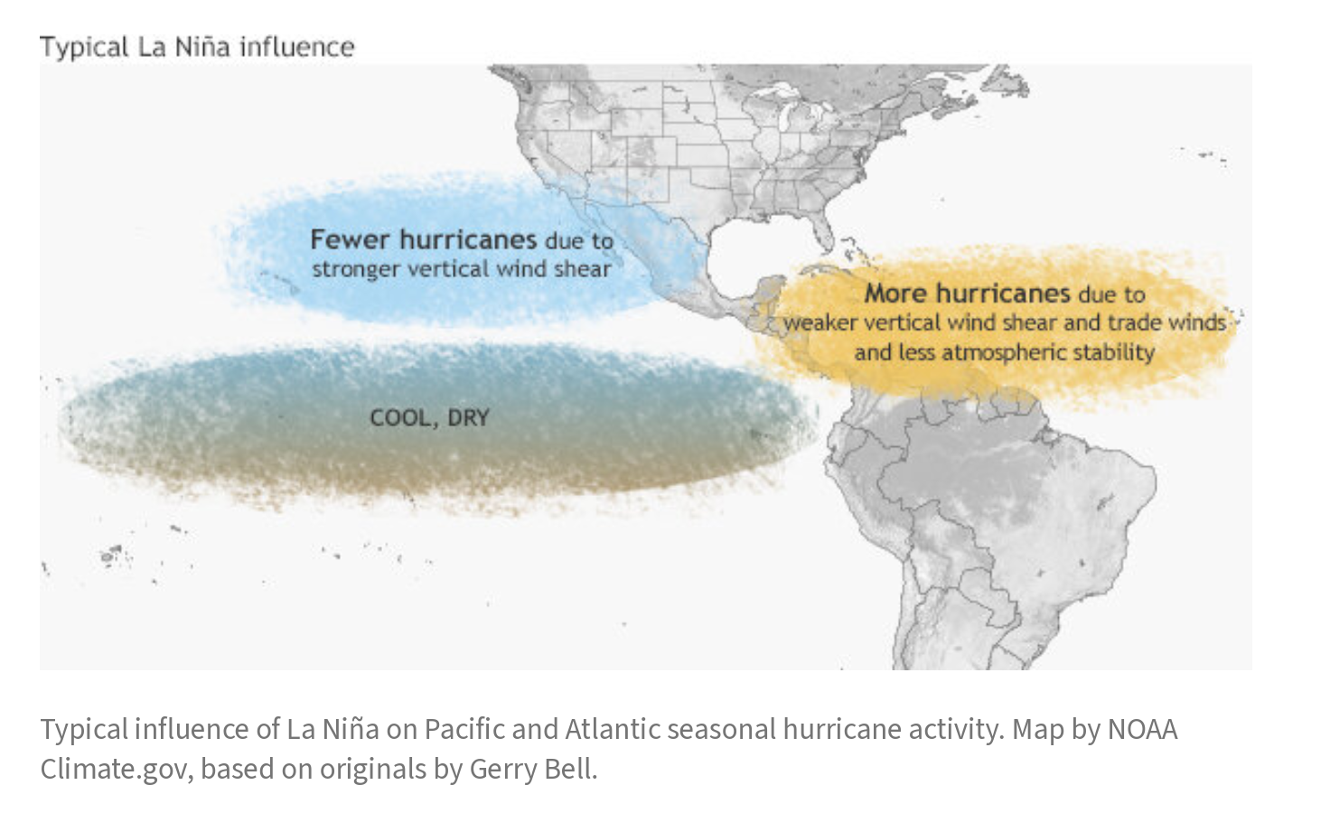
The potentially active 2024 season is due to several factors – primarily the El Niño and La Niña phenomena. As reported in a recent Source article, a possible transition from an El Niño pattern to La Niña, along with the combination of warmer-than-normal sea surface temperatures, may contribute to an increase in cyclones developing in the Atlantic Ocean and Caribbean Sea.
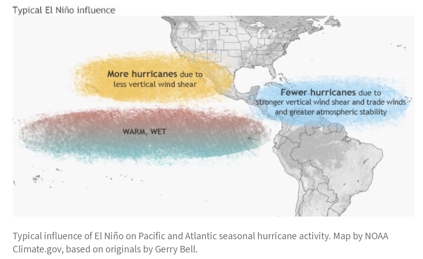
During a La Niña cycle, the waters across the equatorial Pacific Ocean cool significantly, affecting global weather. During La Niña, wind shear — a change in wind direction and velocity with height in the atmosphere — also typically decreases in the Atlantic Ocean. A reduction in wind shear can favor cyclone development. This pattern is the opposite of El Niño, a warming of the equatorial Pacific, which usually increases wind shear in the Atlantic Ocean, helping to rip apart storms and preventing hurricane formation and intensification. A cycle of El Niño has been occurring since June 2023.
“Scientists call [the two opposing climate patterns of El Niño and La Niña] the ‘El Niño-Southern Oscillation’ (ENSO) cycle. El Niño and La Niña can both have global impacts on weather, wildfires, ecosystems, and economies,” according to the National Oceanic and Atmospheric Administration.
A neutral phase of ENSO occurs when neither El Niño nor La Niña are happening.
“ENSO-neutral refers to periods when neither El Niño nor La Niña is present,” according to information from the National Weather Service. “These periods often coincide with the transition between El Niño and La Niña events. During ENSO-neutral periods, the ocean temperatures, tropical rainfall patterns, and atmospheric winds over the equatorial Pacific Ocean are near the long-term average [based on historical weather records],” the NWS explained. (Notably, an ENSO-neutral phase may also result in lower wind shear across the Atlantic, which may result in more favorable conditions for cyclones to develop.)
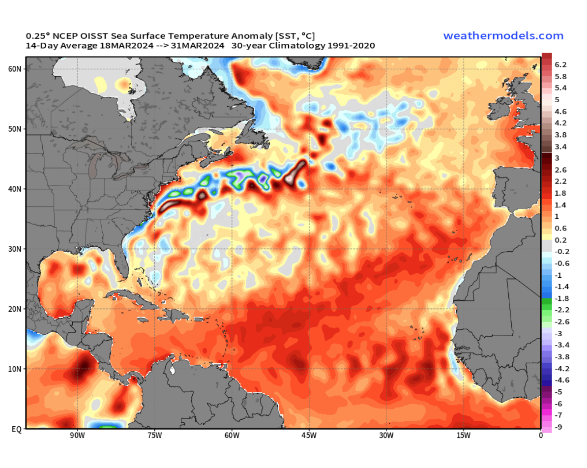
In addition to low wind shear allowing a cyclone to intensify, warm sea surface temperatures further strengthen a storm. As a hurricane moves across warm water, the system can strengthen as it pulls in water vapor and heat, causing evaporation rates to rise. Sea surface temperatures are already above average and are expected to continue to rise.
Other influences on cyclone development include rapid intensification, the amount of available moisture in the atmosphere and the strength of the upper-level winds that transport tropical waves off the coast of western Africa.
AccuWeather Meteorologists Call for Similar Record-Breaking Conditions
While the CSU report is quite jarring, additional weather organizations have predicted a very active season. For example, a recent report from AccuWeather called for an “explosive” 2024 hurricane season.
“AccuWeather meteorologists are forecasting 20-25 named storms across the Atlantic basin in 2024, including 8-12 hurricanes, four to seven major hurricanes, and four to six direct U.S. impacts,” according to the AccuWeather report. “This is all above the 30-year historical average of 14 named storms, seven hurricanes, three major hurricanes, and four direct U.S. impacts,” the article said.
In a statement to the Source, AccuWeather Lead Long-Range Forecaster and Senior Meteorologist Paul Pastelok noted that the timing of the ENSO cycle was a significant forecast consideration. He explained that a La Niña pattern could occur during the latter part of the summer and at the height of hurricane season.
“It is not just about whether we are going into a La Niña (a favorable phase for tropical development) or El Niño (a non-favorable [phase for tropical development]); it is the timing when they end and start that can make a difference, especially around the peak of the season from August through October,” Pastelok said. “El Niño is weakening quickly [and is expected to turn] to neutral by early summer, and then change to La Niña, we believe by late summer, during the peak of hurricane season,” he added.
Pastelok explained that a semi-permanent, subtropical area of high pressure in the Atlantic known as the Bermuda/Azores High can also affect the direction and path that developing storms may take. With so many factors to consider, Pastelok offered the following advice regarding the possibility of cyclones impacting the USVI and Puerto Rico this year.
“Regarding the Virgin Islands and Puerto Rico, many systems may track north and south of the region, which is not uncommon,” Pastelok said. “However, with the above-average number of storms forecasted this season, the potential is high that a few storms will come very close to the islands with some impact,” he warned.
Differences in Weather Forecasts
Weather forecasts issued by various organizations can vary, which is also true for tropical cyclone forecasts. This has much to do with differences in computer forecasting models and which models are used to produce a specific forecast.
The Source asked Sim Aberson, a meteorologist at the Atlantic Oceanographic and Meteorological Laboratory’s Hurricane Research Division, part of NOAA, about forecast differences. Aberson explained that NOAA utilizes a consensus of multiple computer models and information to make weather predictions. However, weather organizations may rely more heavily on only one forecast model, which can result in varying outlooks for future weather depending on the organization that issues the forecast.
“Agencies like NOAA take all the information they have from different models and their knowledge to make their predictions like the National Hurricane Center does when they make their official forecasts every six hours for an individual tropical cyclone,” Aberson said. “These forecasts are generally, though not always, better than the individual [single model] forecasts,” he added.
Aberson noted that individuals should be prepared for a hurricane regardless of forecasts. He reminded readers that even one major hurricane can cause extreme damage.
“If a forecast says there will be six hurricanes this year, it doesn’t say whether the six hurricanes will all be out to sea, make landfall somewhere, or affect the Virgin Islands,” Aberson explained.
“The important point is that, regardless of what these seasonal forecasts say, everyone needs to be prepared because you can have a catastrophic hurricane even in very inactive years,” he stated.
Stay Informed
USVI residents and visitors can find information about the weather, including severe weather alerts, from the Virgin Islands Territorial Emergency Management Agency website and the National Weather Service.
A daily weather post is also published on the Source Weather Page, where readers can view weather forecast videos.

