Updated: June 22 | 11 a.m.
An 11:00 a.m. AST update from the National Hurricane Center (NHC) on Thursday explains that Tropical Storm Bret is moving toward the west at approximately 14 mph, with maximum sustained winds of about 70 mph and higher wind gusts. (This is just shy of the threshold for a category one hurricane.)
Bret is forecast to move through the Lesser Antilles island chain later today as a strong tropical storm. The system is then expected to pass to the south of the USVI and Puerto Rico by Friday night before diminishing later this weekend. The storm will likely encounter more wind shear and drier air after it moves through the Lesser Antilles.
A “Hurricane Watch” is now in effect for St. Lucia. A “Tropical Storm Warning” is also in effect for St. Lucia, as well as for Dominica and Martinique. A “Tropical Storm Watch” is in effect for Barbados and St. Vincent and the Grenadines.
“A ‘Hurricane Watch’ means that hurricane conditions are possible within the watch area, in this case, within the next 24 hours. A ‘Tropical Storm Warning’ means that tropical storm conditions are expected somewhere within the warning area, in this case, within 24 hours. A ‘Tropical Storm Watch’ means that tropical storm conditions are possible within the watch area, in this case within the next 24 hours,” according to the 11 a.m. update from the NHC.
“Interests elsewhere in the Lesser Antilles should monitor the progress of Bret. Additional watches or warnings may be required later today,” the update continues.
Potential Storm Impacts Across the Lesser Antilles
The NHC has shared the following information regarding possible storm impacts across portions of the Lesser Antilles:
WIND:
Hurricane conditions are possible in the hurricane watch area this evening or tonight. Tropical storm conditions are expected within the tropical storm warning areas and possible within the watch areas later today and tonight.
RAINFALL:
Storm total rainfall amounts of 3 to 6 inches with maximum amounts of 10 inches are possible across portions of the Lesser Antilles from Guadeloupe south to St Vincent and the Grenadines, including Barbados. The heavy rainfall could lead to flash flooding, especially across areas of higher terrain. Urban flooding is also possible.
SURF:
Swells generated by Bret are expected to affect portions of the Lesser Antilles through Friday. These swells are likely to cause life-threatening surf and rip current conditions.
As mentioned above, Tropical Storm Bret is forecast to pass south of the USVI, and Puerto Rico and the U.S. territories are not expected to experience the full effects of this system.
Updates on this system and potential impacts to the USVI and Puerto Rico will continue to be published on the Source Weather Page.
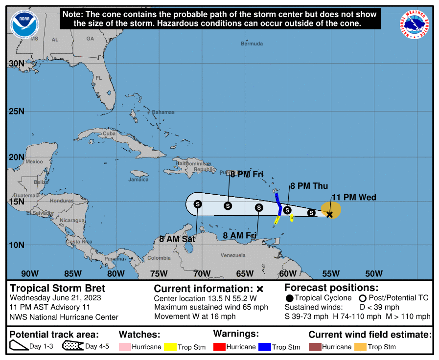
Updated: June 21 | 11 p.m.
The 11:00 p.m. AST update from the National Hurricane Center (NHC) on Wednesday explains that Tropical Storm Bret is moving toward the west at approximately 16 mph, with maximum sustained winds of about 65 mph and higher wind gusts.
Bret is forecast to move through the Lesser Antilles island chain by Thursday evening as a tropical storm. The system is then expected to pass to the south of the USVI and Puerto Rico by Friday night before diminishing this weekend. The storm has encountered wind shear and is unlikely to strengthen as it approaches the Caribbean islands.
A “Tropical Storm Warning” is now in effect for St. Lucia, Dominica, and Martinique. A “Tropical Storm Watch” has been issued for Barbados and St. Vincent and the Grenadines.
“A ‘Tropical Storm Warning’ means that tropical storm conditions are expected somewhere within the warning area within 36 hours. A ‘Tropical Storm Watch’ means that tropical storm conditions are possible within the watch area, in this case within the next 24 to 36 hours,” according to the 11 p.m. update from the NHC.
“Interests elsewhere in the Lesser Antilles should monitor the progress of Bret.
Additional watches or warnings may be required on Thursday,” the update continues.
Potential Storm Impacts Across the Lesser Antilles
The NHC has shared the following information regarding possible storm impacts across portions of the Lesser Antilles:
WIND:
Tropical storm conditions are expected within the warning areas and possible within the watch areas late Thursday and Thursday night.
RAINFALL:
Through Saturday, storm total rainfall amounts of 3 to 6 inches with maximum amounts of 10 inches are possible across portions of the Lesser Antilles from Guadeloupe south to St Vincent and the Grenadines, including Barbados. The heavy rainfall could lead to flash flooding, especially across areas of higher terrain. Urban flooding is also possible.
SURF:
Swells generated by Bret are expected to begin affecting portions of the Lesser Antilles on Thursday. These swells are likely to cause life-threatening surf and rip current conditions.
As mentioned, Tropical Storm Bret is forecast to pass south of the USVI, and Puerto Rico and the U.S. territories are not expected to experience the full effects of this system. However, it is essential to be prepared in the event of changes to the forecast, and updates will be posted as they become available.
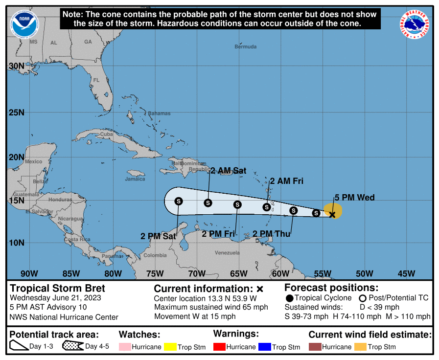
Updated: June 21 | 5 p.m.
The 5:00 p.m. AST update from the National Hurricane Center on Wednesday explains that Tropical Storm Bret is moving westward at approximately 15 mph. The system has slightly strengthened and now contains maximum sustained winds of about 65 mph, with higher wind gusts.
Bret is still expected to move through the Lesser Antilles island chain by Thursday and pass to the south of the USVI and Puerto Rico over the weekend before diminishing. While the storm has encountered wind shear, it may experience some strengthening as it approaches the Caribbean islands.
A “Tropical Storm Warning” is in effect for both St. Lucia and Martinique, and a “Tropical Storm Watch” has been issued for Barbados and Dominica.
“A ‘Tropical Storm Warning’ means that tropical storm conditions are expected somewhere within the warning area within 36 hours. A ‘Tropical Storm Watch’ means that tropical storm conditions are possible within the watch area, in this case within the next 24 to 36 hours,” according to the 5 p.m. update from the NHC.
“Interests elsewhere in the Lesser Antilles should monitor the progress of Bret. Additional watches or warnings may be required tonight,” the update continues.
Potential Storm Impacts Across the Lesser Antilles
The NHC has shared the following information regarding possible storm impacts across portions of the Lesser Antilles:
WIND:
Tropical storm conditions are expected within the warning areas and possibly within the watch areas late Thursday and Thursday night.
RAINFALL:
Through Saturday, storm total rainfall amounts of 3 to 6 inches with maximum amounts of 10 inches are possible across portions of the Lesser Antilles from Guadeloupe south to St. Vincent and the Grenadines, including Barbados. The heavy rainfall could lead to flash flooding, especially across areas of higher terrain. Urban flooding is also possible.
SURF:
Swells generated by Bret are expected to begin affecting portions of the Lesser Antilles on Thursday. These swells are likely to cause life-threatening surf and rip current conditions.
As mentioned, Tropical Storm Bret is forecast to pass south of the USVI, and Puerto Rico and the U.S. territories are not expected to experience the full effects of this system. However, the NHC reminds readers about the uncertainty of the storm’s exact track and intensity. It is important to be prepared, and updates will be posted as they become available.

Updated: June 21 | 11 a.m.
An 11:00 a.m. update from the National Hurricane Center (NHC) on Wednesday notes that Tropical Storm Bret is moving westward at approximately 14 mph. The system has again slightly strengthened and is packing maximum sustained winds of about 60 mph, with higher wind gusts.
Bret is expected to pass through the Lesser Antilles by Thursday and move to the south of the USVI and Puerto Rico over the weekend before weakening. The likelihood of Bret reaching hurricane status has decreased. However, the system may still experience some additional strengthening as it approaches the Caribbean islands.
A “Tropical Storm Warning” is in effect for St. Lucia, and “Tropical Storm Watches” have been issued for several islands across the Caribbean.
“A Tropical Storm Watch is in effect for Barbados, Dominica, and Martinique. A ‘Tropical Storm Warning’ means that tropical storm conditions are expected somewhere within the warning area within 36 hours. A ‘Tropical Storm Watch’ means that tropical storm conditions are possible within the watch area, in this case within the next 24 to 48 hours,” according to the update from the NHC.
“Interests elsewhere in the Lesser Antilles should monitor the progress of Bret. Additional watches or warnings will likely be required for these islands today,” the update continues.
Potential Storm Impacts Across the Lesser Antilles
The NHC shared the following information regarding possible storm impacts across the Lesser Antilles:
WIND:
Tropical storm conditions are expected within the warning area and possible within the watch areas late Thursday and Thursday night.
RAINFALL:
Through Saturday, storm total rainfall amounts of 3 to 6 inches with maximum amounts of 10 inches are possible across portions of the Lesser Antilles from Guadeloupe south to St. Vincent and the Grenadines, including Barbados. The heavy rainfall could lead to flash flooding, especially across areas of higher terrain. Urban flooding is also possible.
SURF:
Swells generated by Bret are expected to begin affecting portions of the Lesser Antilles on Thursday. These swells are likely to cause life-threatening surf and rip current conditions.
The NHC again mentions uncertainty about the storm’s exact track and intensity. Updates will be posted as they become available.
Updated: June 20 | 11 p.m.
An 11:00 p.m. update from the National Hurricane Center (NHC) on Tuesday notes that Tropical Storm Bret is currently moving toward the west at approximately 17 mph. The system has slightly strengthened and now is packing maximum sustained winds of about 50 mph, with higher wind gusts.
The forecast track takes Bret through the Lesser Antilles by Thursday and passes to the south of the USVI and Puerto Rico this weekend. The likelihood of Bret reaching hurricane status has decreased. However, the system may experience some additional strengthening as it approaches the Caribbean islands as a tropical storm.
“Tropical Storm Watches” have been issued for several islands across the Caribbean.
“A Tropical Storm Watch is in effect for Barbados, Dominica, Martinique, and St. Lucia. A Tropical Storm Watch means that tropical storm conditions are possible within the watch area, generally within 48 hours,” according to the 11 p.m. update from the NHC.
“Interests elsewhere in the Lesser Antilles should monitor the progress of Bret. Additional tropical storm watches or warnings will likely be required for these and other islands on Wednesday,” the update continues.
The NHC stresses that uncertainty remains about the storm’s exact track and intensity. Updates will be posted as they become available.

Updated: June 20 | 5 p.m.
A 5:00 p.m. update from the National Hurricane Center (NHC) explains that Tropical Storm Bret is currently moving toward the west at approximately 18 mph, with maximum sustained winds of about 45 mph, with higher wind gusts.
The latest forecast track from the NHC takes Bret into the Caribbean, passing to the south of the USVI and Puerto Rico this weekend. The advisory mentions that the system has likely encountered some wind shear, which may continue over the next few days. The likelihood of Bret reaching hurricane status has now slightly decreased. Still, the system is expected to experience some additional strengthening as it approaches the Caribbean islands.
“Bret is forecast to approach the Lesser Antilles through Thursday morning and then move across the islands Thursday afternoon and Thursday night as a tropical storm, bringing a risk of
flooding from heavy rainfall, strong winds, and dangerous waves along the coast,” according to the NHC update.
“A Tropical Storm Watch has been issued for Barbados, and additional watches are likely for other islands within the Lesser Antilles later tonight,” the update continues.
The NHC stresses that uncertainty remains about the storm’s intensity and track. Additional updates will be posted as they become available.
Updated: June 20 | 11 a.m.
An 11 a.m. update from the National Hurricane Center (NHC) explains that Tropical Storm Bret is currently moving toward the west at approximately 21 mph, with maximum sustained winds of about 40 mph.
The latest forecast track from the NHC takes Bret into the Caribbean, passing to the south of the USVI and Puerto Rico this weekend. The advisory mentions that the system has likely encountered wind shear, and this may continue over the next few days, meaning that the likelihood of Bret reaching hurricane status has decreased.
“Bret’s forecast intensity in the NHC prediction has been decreased, still allowing for the possibility of some strengthening, but keeping the system below hurricane strength,” according to the NHC update.
Regardless of the strength of the system, the NHC warns that flooding rains are possible across portions of the Caribbean, and uncertainty remains about the intensity and track of the storm. Additional updates will be posted as they become available.
June 19 | 8 p.m.
A tropical wave that has been monitored for several days by the National Hurricane Center has been upgraded to a tropical storm. The system has been given the name Bret, the second named storm of the 2023 Atlantic Hurricane Season. The latest forecast track takes the storm into the Caribbean region as a possible hurricane by this coming weekend.
As of 5 p.m. AST on Monday, Tropical Storm Bret is currently moving westward at approximately 21 mph, with maximum sustained winds of at least 40 mph. Bret is expected to continue to intensify, and computer forecast models indicate that this storm may reach hurricane status as it potentially crosses south of the USVI and Puerto Rico.
It is important to remember that the current forecast track and possible cyclone intensity are still uncertain.
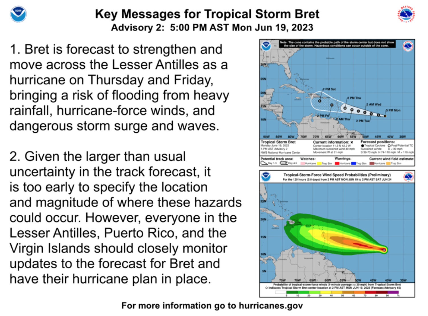
“Tropical Storm Bret has formed, and the current track has the system moving just south of the local islands by the end of the workweek into the weekend. However, uncertainty is really high with this system, and adjustments are likely with future advisories,” according to an update from the National Weather Service in San Juan, Puerto Rico, on Monday afternoon.
2023 Atlantic Cyclone Development
It is relatively early in this year’s hurricane season, and this storm is already the second named cyclone this year. The first named storm was Arlene, which formed on June 2 in the Gulf of Mexico. An update on “The Weather Channel” mentions that the reason for tropical development early in the season may be connected to very warm ocean temperatures.
“This would be very unusual for June, as most June storms develop in the Gulf of Mexico or off the East Coast,” according to the Weather Channel update.
Still, tropical systems forming during the month of June are not necessarily an anomaly. For example, during the 2022 Atlantic Hurricane Season, Tropical Storm Alex formed in June, followed by two additional cyclones in July. August was extremely quiet before the tropics unleashed very destructive systems during the months of September and October, including hurricanes Fiona and Ian.
Looking Ahead
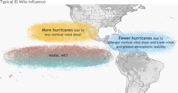
An El Niño weather pattern has officially been declared by the National Oceanic and Atmospheric Administration (NOAA). El Niño can help to suppress tropical activity in the Atlantic. However, very warm ocean temperatures currently observed in the Atlantic and Caribbean can aid in fueling the growth of storms.
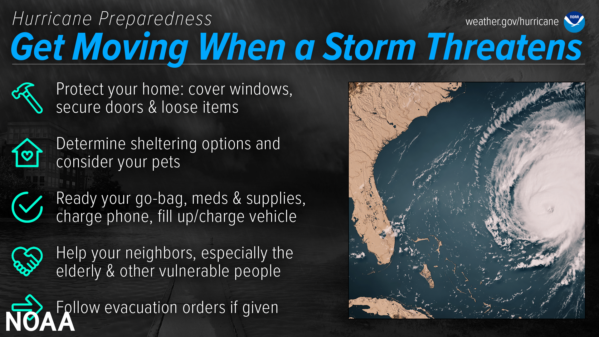
Ultimately, awareness about and preparation for cyclones are fundamental during hurricane season. Click here to read a detailed list from the National Weather Service about hurricane preparedness.
In addition to Tropical Storm Bret, a second tropical wave, designated “Invest 93L,” is being monitored by the NHC. Tropical updates and weather alerts from the National Hurricane Center will consistently be posted to the Source Weather Page.
Finally, USVI visitors and residents can find information about emergency shelters and alerts from the Virgin Islands Territorial Emergency Management Agency.

