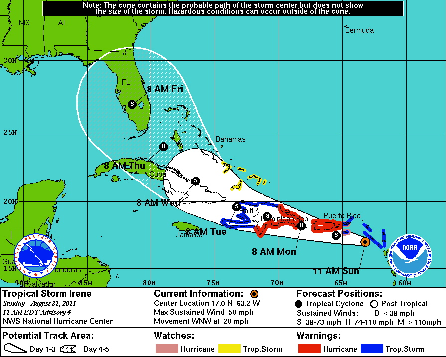
“The center of circulation developed a little bit to the north,” said Jose Alamo, a meteorologist at the National Weather Service in San Juan, at 6:30 a.m. Sunday.
Alamo expects Irene to intensify as the storm makes its way closer to the territory.
The territory remains on a tropical storm warning, but a hurricane watch was also posted at 11 a.m. This means that hurricane conditions are possible. A flash flood advisory remains in place.
Winds are still at 50 mph and they still extend outward 150 miles to the north and east of the center, the same as they were when the National Hurricane Center named Irene on Saturday, but its closer path means more wind and rain for the territory. And wind gusts could approach hurricane strength.
Conditions are expected to get worse as the morning progresses. Alamo said the center will be 28 miles south southwest of St. Croix at 7 p.m. Sustained winds are expected to hit 55 mph with gusts to 65 mph. Tropical storm force winds of 39 mph or higher will start to affect St. Croix around 2 p.m.
At 7 p.m., the center will be 76 miles south southwest of St. John and at 9 p.m., 73 miles from St. Thomas. Sustained winds are expected to hit 50 mph with gusts to 65 mph.
Alamo said four to seven inches of rain are expected across the territory, with 10 inches falling in isolated areas.
At 9:30 a.m., Irene’s center was 200 miles east southeast of St. Croix.
Irene is moving west northwest at 20 mph. It’s centered at 17 degrees north latitude and 63.2 degrees west longitude. The barometric pressure stands at 1005 millibars.
U.S. Coast Guard spokesman Ricardo Castrodad said at 11 a.m. that all ports are closed to inbound traffic and on St. Croix will be closed to outbound traffic at noon. The Coast Guard is waiting to see how the weather develops before closing those St. Thomas and St. John ports to outbound traffic. No one answered the phone at either Varlack Ventures or Transportation Service so information on ferry operations between St. Thomas and St. John was not available, but Castrodad said those ports remain open until the port captain decides to close them.
The V.I. Territorial Emergency Management Agency advised early Sunday morning that citizens should rush to complete preparations for the protection of life and property. It suggested residents be prepared to evacuate if directed to do so by local officials or if their home is vulnerable to high winds or flooding. Interests at ports, docks and marinas are urged to complete preparations according to their emergency operations plan for tropical cyclones.
Boaters are urged make final preparations for securing their craft before leaving it. Regarding any coastal waters under a warning, small craft should remain in port and well secured.
Castrodad took that one step further and warned people to stay out of the water.
“This is not the time to go surfing,” he said.


