
The National Weather Service (NWS) in San Juan, Puerto Rico, has explained that a very wet and unstable weather pattern will continue to occur across the local islands over the coming days. Several weather alerts, such as a Flash Flood Watch, have been issued for portions of the U.S. Virgin Islands and Puerto Rico.
“A series of mid-to-upper-level troughs [areas of low pressure] and above-normal moisture from a nearly stationary front [which the NWS defines as a boundary or transition zone between two air masses of different density, and usually of different temperature] will create ideal conditions for thunderstorm development over the next few days,” according to an update from the NWS on Wednesday.
“The most intense and frequent activity [is] expected between Thursday morning and Saturday morning, [and] rainfall totals during this period are expected to range from three to six inches, with locally higher amounts of [up to] eight to 10 inches across northern and eastern Puerto Rico, Vieques, Culebra, and the U.S. Virgin Islands,” the NWS said. “Elsewhere [across the region], expect rainfall amounts around one to two inches,” the NWS added.
The potential for heavy rain and hazardous marine conditions has resulted in weather alerts for the USVI and Puerto Rico. A Flash Flood Watch will be in effect from 8 a.m. on Thursday until 8 a.m. on Saturday.
“A Flash Flood Watch has been issued due to the high likelihood that any extended period of moderate to heavy rainfall will lead to flash flooding, [including] sudden river surges—potentially causing some rivers to exceed flood-stage levels—and mudslides in areas with steep terrain,” the NWS explained.
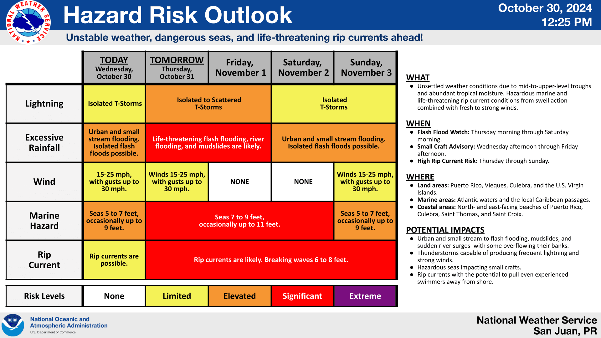
Additionally, choppy seas, strong rip currents, and gusty winds are forecast, and marine alerts have been announced for the local islands. A Small Craft Advisory will be in effect from 8 a.m. on Thursday until 6 a.m. on Saturday, and a High Rip Current Risk will be in effect from 6 a.m. on Thursday until 6 a.m. on Saturday.
“Hazardous marine and life-threatening rip current conditions from [large] swell action combined with fresh to strong winds are expected from Thursday onward,” the NWS warned.
National Hurricane Center Monitoring Caribbean
As was reported by The Source earlier this week, inclement weather may continue through the first week of November due to a tropical disturbance that could develop in the southwestern Caribbean. The National Hurricane Center (NHC) is closely monitoring an area with a medium chance of cyclonic development.
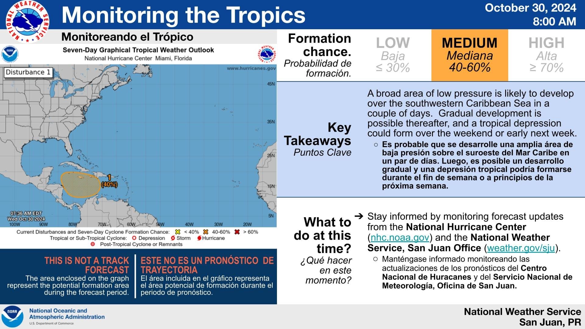
“A broad area of low pressure is likely to develop over the southwestern Caribbean Sea by the end of the week,” according to an update from the NHC on Wednesday. “Gradual development is possible thereafter, and a tropical depression could form over the weekend or early next week while the system drifts generally northward or northwestward over the central or western Caribbean Sea,” the NHC continued.
Weather Updates
USVI residents and visitors are reminded that weather forecast information, including severe weather alerts, is available from the Virgin Islands Territorial Emergency Management Agency website and the National Weather Service. Individuals are also encouraged to monitor updates from the National Hurricane Center throughout the remainder of hurricane season, which officially ends on Nov. 30.
The Source Weather Page also publishes a daily weather forecast and offers readers the opportunity to view weather forecast videos and disaster preparedness video segments.


