The 2024 Atlantic Hurricane Season officially ends on Nov. 30, but with more than a month remaining, the forecast continues to suggest the potential for cyclonic development.
The Source contacted Matt Rosencrans, National Weather Service Lead Hurricane Seasonal Forecaster, to obtain an update on what may occur regarding tropical development for the rest of the season. Rosencrans explained that there will be a risk of development across the Caribbean and the Atlantic.
Cyclonic Development Across Atlantic and Caribbean
“I think the remainder of the season could include some more activity,” Rosencrans said. “The Caribbean Sea surface temperatures (SST) are still [the] second warmest [on record] since 1981, and Gulf of Mexico SSTs are still the warmest on record [according to information from the Optimum Interpolation Sea Surface Temperature dataset, associated with the National Oceanic and Atmospheric Administration],” Rosencrans explained.
Rosencrans pointed out that, based on climatology, cyclonic development occurs less frequently across the Main Development Region (MDR) of the Atlantic, an area between the west coast of Africa and the Lesser Antilles. Still, tropical waves over the MDR are possible in the coming weeks.
“The [atmospheric conditions] that create the waves over Africa is waning, as it does every year around this time, but it’s not yet done,” Rosencrans warned. “The latest model outlooks [predicted] two [tropical] waves [during the current] week, and then there could be another couple [of tropical waves emerging off the west coast of Africa] after that,” Rosencrans continued. “Later in the season, the Caribbean and [the] Gulf of Mexico become the favored spots for tropical storm development [based on climatology], as the African Easterly [Tropical] Waves diminish [and] the West African Monsoon wanes,” Rosencrans stated.
So far this year, several notable systems have occurred near the U.S. Virgin Islands, including Tropical Storm Ernesto’s trek across the territory in August. Additionally, destructive Hurricane Beryl rapidly intensified into a major hurricane, devastatingly impacting portions of the Caribbean in July.
U.S. Mainland Impacts Through Remainder of Hurricane Season
The United States mainland has been pummeled particularly hard throughout this year’s hurricane season. Five cyclones have made landfall across the mainland as of the writing of this article, including Hurricane Milton, which made landfall near Sarasota, Florida, at the beginning of October, and Hurricane Helene, which crashed into Florida’s Big Bend region before causing catastrophic flooding across the southeastern U.S. in September.
Over the past few weeks, areas of high pressure have helped to protect the southeastern states, nudging tropical systems away from the area. When asked about the potential for another cyclone to strike the U.S. mainland before the season is over, Rosencrans explained that it is a distinct possibility that a storm could form and take a track between periods of higher pressure, which might allow a system to affect the mainland.
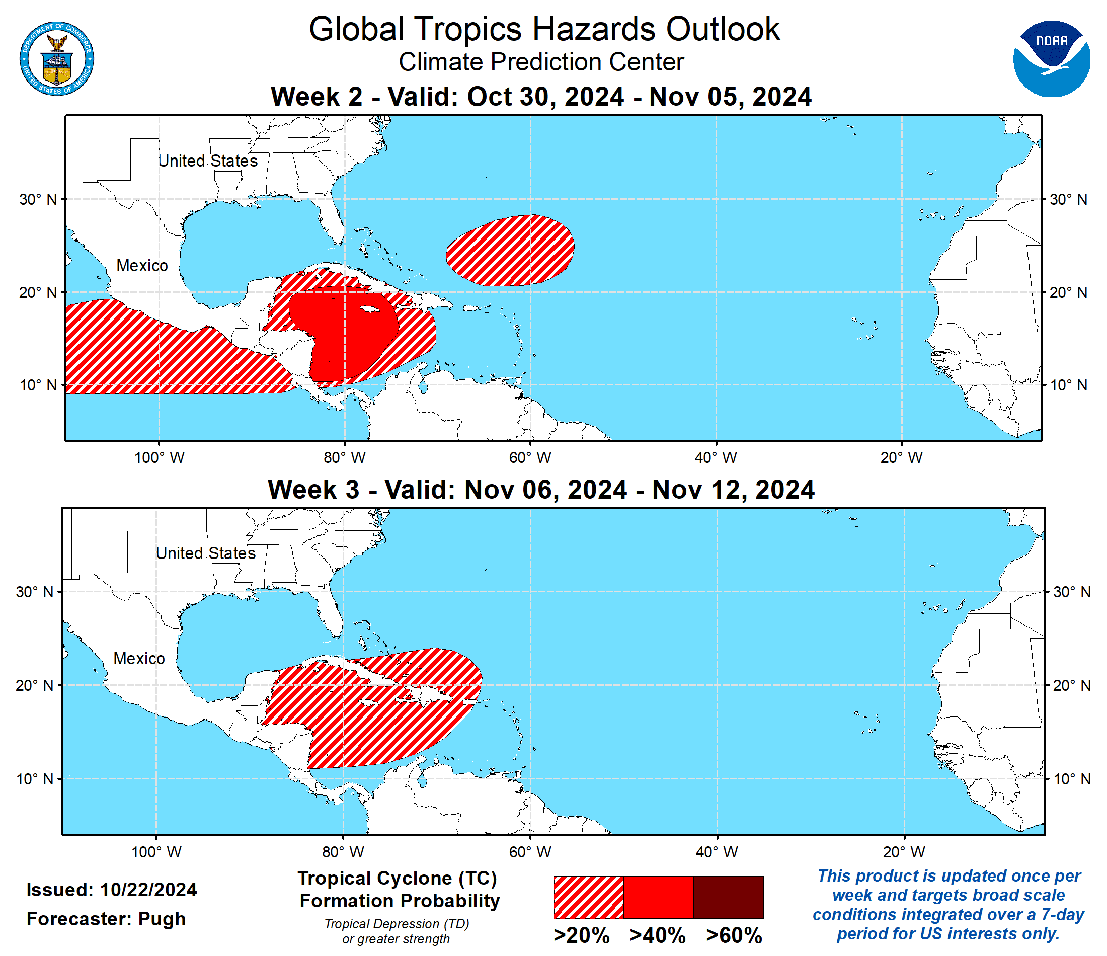
Indeed, the Climate Prediction Center’s Global Tropics Hazards Outlook indicates an elevated risk of cyclonic development near the western Caribbean over the next few weeks, and particularly during the week of Oct. 30 to Nov. 5. Individuals located in this area are encouraged to remain vigilant.
“Tropical storm tracks are very difficult to predict more than about a week out,” Rosencrans acknowledged.
An Emerging La Niña Weather Pattern
For months, meteorologists have predicted a transition into a La Niña weather pattern, and the latest forecast continues to expect an emergence of La Niña soon.
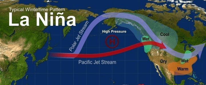
During a La Niña cycle, the ocean waters across the equatorial Pacific Ocean cool significantly, affecting global weather. During La Niña, wind shear—a change in wind direction and velocity with height in the atmosphere—also typically decreases in the Atlantic Ocean. A reduction in wind shear can favor cyclone development. This pattern is the opposite of El Niño, a warming of the equatorial Pacific, which usually increases wind shear in the Atlantic Ocean, helping to rip apart storms and prevent hurricane formation and intensification.
“Scientists call [the two opposing climate patterns of El Niño and La Niña] the ‘El Niño-Southern Oscillation’ (ENSO) cycle. El Niño and La Niña can both have global impacts on weather, wildfires, ecosystems, and economies,” according to NOAA.
A La Niña Watch is currently in effect, an alert that is “issued when conditions are favorable for the development of La Niña conditions within the next six months,” according to the National Weather Service. Nevertheless, if a La Niña pattern sets up, it may not last long.
The CPC has noted that a “La Niña is favored to emerge [between] September-November [with a] 60 percent chance [of development,] and [the cycle] is expected to persist through January-March 2025.”
“[A] La Niña [weather pattern] is likely to [continue] to progress,” Rosencrans explained. “Vertical wind shear over the Caribbean has been quite low over the last 30 days, and it is likely to remain low,” he said.
“[However,] wind shear over the Gulf of Mexico is picking up, as it does every year as we transition into winter,” Rosencrans stated. [Therefore,] putting [all of these components together], I think the rest of the season could have a couple more tropical storms,” he noted. “A normal [season] would [have one or two systems form], and in a year with such warm SSTs, [the number] of cyclones that may continue to form could be slightly higher than the normal.”
Rosencrans also noted that if a La Niña does take hold, computer forecast models show that the Caribbean may experience a wet winter season.
“The [CPC’s] North American Multi-Model Ensemble [computer forecast models] show a wet pattern during the winter for the Caribbean and [a] dry [winter season] for the southeastern U.S., [which is] close to [the] composites of La Niña events,” Rosencrans stated.
Remain Prepared Through Hurricane Season
Rosencrans concluded his comments by sharing what he has found noteworthy thus far in the 2024 Atlantic Hurricane Season.
“This season has been interesting [due to] both the lack of early September [tropical] activity and the incredible burst of late September to early October [tropical] activity, [which was] record-breaking [between] Sept. 24 through Oct.12,” Rosencrans revealed. “The loss of life during [the five hurricanes that have made landfall across the United States so far] is heartbreaking,” he added. “[Moving forward,] the team at NOAA will set out to see what can [be learned] from this year to advance our predictions and hopefully minimize future loss of life and suffering,” he said.
USVI visitors and residents are encouraged to stay up to date with forecasts from the NHC. Hurricane preparedness tips are available from the Virgin Islands Territorial Emergency Management Agency and NOAA.
Weather forecast information, including severe weather alerts, is available from the VITEMA website and the National Weather Service.
Additionally, the Source Weather Page publishes a daily weather forecast and offers readers the opportunity to view weather forecast videos and disaster preparedness video segments.


