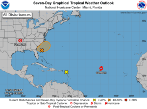
The National Hurricane Center (NHC) is watching some active areas for possible cyclonic development over the next seven days. One system, named “Invest 94L,” is forecast to bring an elevated chance for precipitation across the Virgin Islands and Puerto Rico this weekend.
“A tropical wave [Invest 94L] continues to be monitored by the National Hurricane Center (NHC), [and] is located over the U.S. Virgin Islands and moving toward Puerto Rico,” according to an update on Friday from the National Weather Service (NWS) in San Juan, Puerto Rico. “This wave is expected to continue to deteriorate the local weather conditions through at least Sunday,” the NWS continued. (An “invest” is an area under investigation by the NHC for possible cyclonic development.)
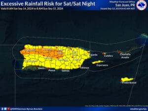
The NWS has explained that minor flooding is possible due to the potential for excessive rainfall associated with the tropical wave.
“Abundant moisture associated [with] this wave, in combination with daytime heating and local effects, will result in moderate to heavy shower development across western Puerto Rico during the afternoon hours,” the NWS explained. “Urban and small stream flooding, and quick river rises are possible with this activity,” the NWS warned.
Continue to Stay Prepared During Hurricane Season
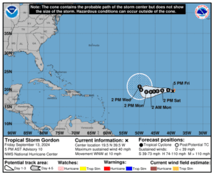
In addition to Invest 94L, the NHC has reported that Tropical Storm Gordon has formed in the Atlantic. Gordon is the seventh named cyclone of the 2024 Atlantic Hurricane Season.
As of 5 p.m. on Friday, Tropical Storm Gordon was packing winds of approximately 40 mph and was traveling to the west-northwest at approximately 10 mph. The current forecast calls for the system to stay out to sea while encountering unfavorable conditions for significant intensification.
The NHC also continues to track the remnants of Hurricane Francine, which made landfall as a Category 2 hurricane across Louisiana earlier this week. An area of low pressure off the southeastern U.S. is also being monitored.
Before the start of hurricane season this year, forecasters had called for an extremely busy 2024 Atlantic Hurricane Season. It remains to be seen how many storms will ultimately materialize through the remainder of the season, which ends on November 30. Regardless of how many additional cyclones may form, the season has already been record-breaking, particularly due to destructive Hurricane Beryl, which rapidly intensified into a major hurricane and brought devastating impacts to portions of the Caribbean in July.
V.I. residents and visitors are reminded that the weather forecast can change quickly, and it is essential to stay up to date with forecasts from the NHC. Hurricane preparedness tips are available from the Virgin Islands Territorial Emergency Management Agency and the National Oceanic and Atmospheric Administration.
Finally, excessive heat is forecast to continue across the area, and staying hydrated and cool is essential to help avoid heat-related illnesses.
Weather Updates
Weather forecast information, including severe weather alerts, is available from the VITEMA website and the National Weather Service.
The Source Weather Page also publishes a daily weather forecast and offers readers the opportunity to view weather forecast videos and disaster preparedness video segments.


