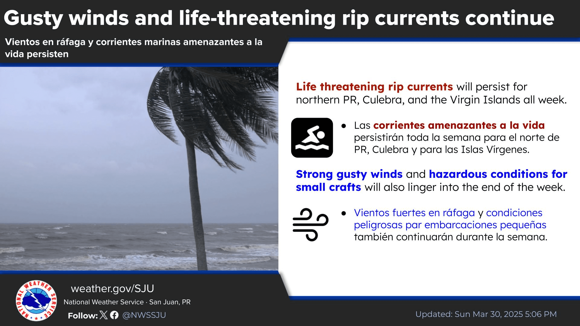
The National Weather Service in San Juan, Puerto Rico, has warned that winds will be gusty across the local region throughout the week, and showers and thunderstorms are possible. Additionally, seas will be hazardous, and marine alerts are currently in effect.
The NWS noted that winds may be particularly hazardous during the latter part of the week.
“Variable and showery weather conditions are expected [to continue], and breezy to windy conditions will be present through the work week, particularly on Thursday and Friday,” according to an update from the NWS Monday. “As a result, [there will be] hazardous and rough seas across most local waters and life-threatening rip currents [will likely occur],” the NWS said.
The NWS explained that the breezy weather is partly due to a robust area of high pressure in the Atlantic Ocean. The strong winds may drag moisture across the islands, and rainfall and thunderstorms are possible over the next few days. Forecasters noted that wind gusts could sometimes reach 25 to 30 miles per hour or higher.
“Wind gusts of 35 mph or more cannot be ruled out, especially over windward and coastal areas of the islands,” the NWS cautioned. “These conditions may result in unsecured outdoor items being blown around or damaged. Winds are expected to subside over the [coming] weekend,” the NWS added.
Current Marine Alerts
The NWS stated that the powerful winds will continue to generate choppy seas, and several marine weather alerts will be in effect.
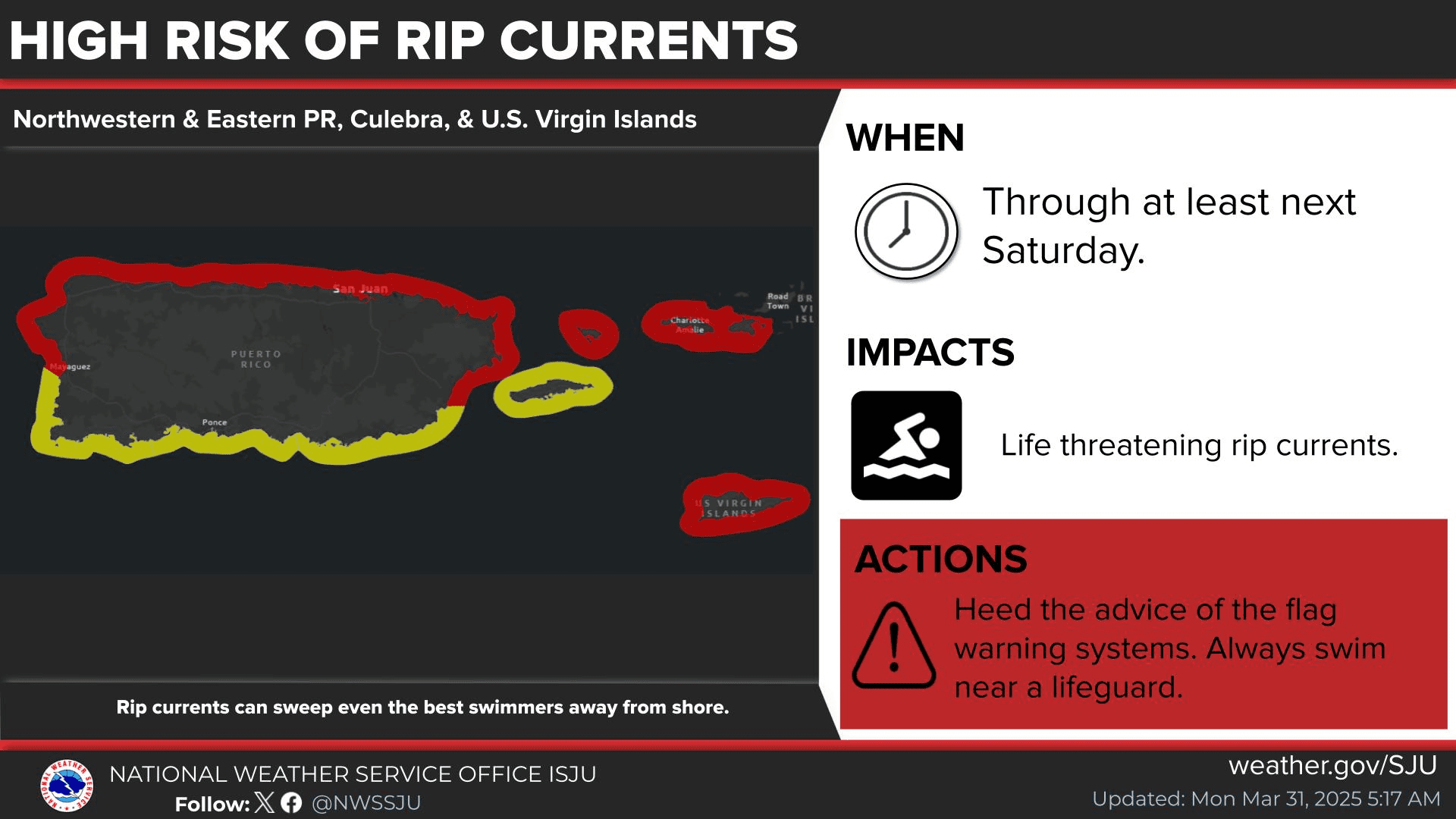
“A surface high pressure over the western Atlantic will continue to promote fresh to locally strong easterly winds throughout most of the workweek,” the NWS said. “Seas will continue to build between six and nine feet across the regional waters during the next several days, [and] as a result, hazardous seas are anticipated for most of the local waters through much of the workweek,” the NWS continued.
A High Rip Current Risk will be in effect for areas of Puerto Rico and the USVI until at least 6 p.m. on Saturday. Additionally, a Small Craft Advisory will be in effect for portions of the local waters until at least midnight on Saturday.
How to Escape a Rip Current and Stay Safe
A previous Source article explained detailed information about rip currents and how to stay safe, and the NWS lists helpful and potentially lifesaving instructions (included below) for individuals caught in a rip current.
The most important factors to remember if caught in a rip current are:
- Relax. Rip currents don’t pull you under.
- A rip current is a natural treadmill that travels an average speed of one to two feet per second but has been measured as fast as eight feet per second — faster than an Olympic swimmer. Trying to swim against a rip current will only use up your energy — energy you need to survive and escape the rip current.
- Do NOT try to swim directly to shore. Swim along the shoreline until you escape the current’s pull. When free from the pull of the current, swim at an angle away from the current toward shore.
- If you feel you can’t reach the shore, relax, face the shore, and call or wave for help. Remember: If in doubt, don’t go out!
- If at all possible, only swim at beaches with lifeguards.
- If you choose to swim on beaches without a lifeguard, never swim alone. Take a friend who has a cellphone, so that person can call 911 for help.
Weather Updates
Finally, hurricane season begins on June 1 and lasts until November 30. With a potentially busy season ahead, residents and visitors are urged to remain informed about the weather.
Weather forecast information and severe weather alerts are available from the Virgin Islands Territorial Emergency Management Agency’s website and the National Weather Service.
The Source Weather Page also publishes a daily weather forecast and allows readers to view weather forecast videos and disaster preparedness video segments.

