Less than a year away from the 2026 primary elections, the V.I. Democratic Party is calling for updates to local election laws after a federal judge voided multiple unconstitutional provisions in 2024. (Source photo by Susan Ellis)
One year and seven months after a federal judge declared that multiple provisions of U.S. Virgin Islands elections law were unconstitutional, the local Democratic Party is calling on lawmakers to codify changes guaranteeing autonomy for territorial political parties to elect their own officers and vet their own candidates.
V.I. Democratic Party Chair Carol Burke told the Source Monday that Virgin Islanders will always prefer to have a primary election.
“We like the objectivity of having the government run the election,” she said, but the party regularly fields questions from voters about candidates running under their banner, and there was absolutely nothing we could do. Our hands were tied.”
At issue is a January 2024 ruling which found multiple provisions of local elections law to be unconstitutional. The judgment came after the Republican National Committee and the territory’s Republican Party sued the V.I. Elections Board and the Elections System’s Supervisor, Caroline Fawkes, in 2022. The plaintiffs in that case argued that political organization is guaranteed by the First Amendment and that the internal workings of political parties should be free from government oversight like any other private organization.
Chief Judge Robert Molloy of the U.S. District Court of the Virgin Islands ultimately voided 10 local provisions and found that two others were preempted by existing federal laws. Molloy’s order prohibited Elections officials from enforcing the voided laws.
In a statement sent to local media outlets this week, Burke called the ruling “a turning point for democracy in the Virgin Islands.”
“The people choose the party, and the party chooses its candidates. Anything less undermines the First Amendment and will of party members,” she said. Speaking to the Source Monday, Burke said lawmakers now needed to put infrastructure in place to make elections more transparent and in line with the ruling.
“Meaning that it was codified so that this party has access to the ballot,” she said. “The process would include the party, to define to the supervisor of elections that ‘these 10 people that you have already deemed eligible because they meet all requirements set forth by the government,’ that based on our own standards — and we will have, for instance, their dues, are they in good standing, that kind of thing … there are quite a number of things that we plan to implement — that they’ve met these requirements and as such, they’re certified to run in the primary election as a Democrat.”
Burke testified before the Senate Government Operations, Veterans Affairs and Consumer Protection Committee Aug. 8 after Sen. Alma Francis Heyliger introduced legislation codifying processes for political parties to choose their candidates for public office. Highlighting a voided provision stating that the Elections Board “will be responsible for certifying the process to be used by any political party to select party officers and candidates for public office,” Francis Heyliger said she saw where the law needed to be fixed ahead of the next election cycle. During her own prepared testimony, Burke called the committee meeting “the perfect opportunity to begin to reset and clarify the standards governing the role of political parties in primary elections.”
“This is a pivotal moment — one that allows us to reaffirm our commitment to constitutional principles and electoral integrity,” she said before acknowledging her counterparts in the Republican Party for filing the legal challenge, which she said “opened the door for all parties — Democratic, Republican and others — to reassert their autonomy and responsibility in the electoral process.”
Burke recommended several amendments to the bill, which later failed to advance out of committee for lack of a second. Speaking to the Source, Burke acknowledged the difficulty of convincing elected officials to change the same election laws that put them in office.
“It’s a very, very tall order, but it’s a judge’s order — I mean, pun intended,” she said. “It’s still a judge’s order. They have to fix it. If we have to go to court and get over this, we will.”
Burke again credited the Republican Party for their legal challenge, which she said showed that the territory was operating under unconstitutional laws.
“The way we felt — we felt real uncomfortable. The party should feel comfortable with its candidates,” she said. “I can tell you, we were not always comfortable, and we had members, voters, coming to us and questioning the process. And we kept saying, ‘there’s nothing we could do because that’s how the law is written.’”
As Hurricane Erin moves away from the U.S. Virgin Islands and Puerto Rico, the National Hurricane Center is monitoring two additional tropical waves crossing the Atlantic. One of the waves has a moderate chance of development and could strengthen as it approaches the Leeward Islands later this week.
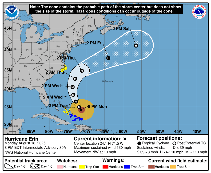
As of the 8 p.m. Monday update from the NHC, Hurricane Erin was located about 695 miles southwest of Bermuda, moving northwest with maximum sustained winds of 130 mph, currently a Category 3 cyclone. The storm’s core is forecast to remain over water, but weather alerts have been issued for the Bahamas, Turks and Caicos, and parts of the U.S. East Coast due to potential impacts.
Hurricane Erin’s projected storm track as of 8 p.m. Monday. The storm continues to move away from the USVI and Puerto Rico and may bring impacts to areas including the Bahamas, Turks and Caicos, and the east coast of the USA. (Photo courtesy NHC)
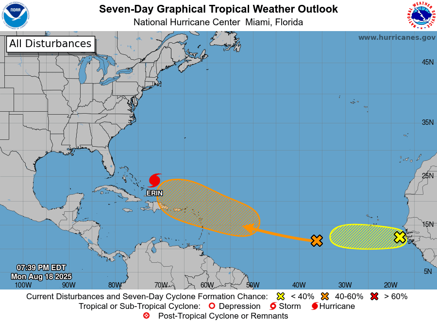
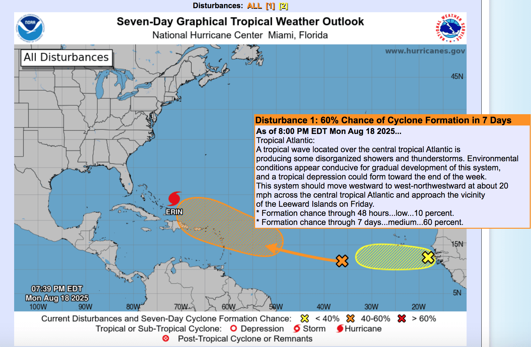
Closer to the U.S. Virgin Islands and Puerto Rico, the National Hurricane Center is monitoring Disturbance #1, a tropical wave in the central Atlantic with a moderate chance of development in the coming days. Another system, Disturbance #2, is also being watched, though it has a low chance of development. Residents and visitors are urged to remain prepared and monitor official updates.
As of 8 p.m. Monday, the NHC provided the following update regarding Disturbance #1:
“A tropical wave located over the central tropical Atlantic is producing some disorganized showers and thunderstorms. Environmental conditions appear conducive for gradual development of this system, and a tropical depression could form toward the end of the week. This system should move westward to west-northwestward at about 20 mph across the central tropical Atlantic and approach the vicinity of the Leeward Islands on Friday,” the NHC said.
The NHC also shared information about Disturbance #2:
“A tropical wave located just off the coast of Africa is producing a persistent cluster of disorganized showers and thunderstorms. Some slight development of this system is possible over the next day or two as it moves westward at around 15 mph. On Thursday, this system should reach a less favorable environment, which should reduce its chances for development.”
The NHC is monitoring two tropical waves moving across the central Atlantic regarding the possibility of cyclonic development in the next seven days. (Photo courtesy NWS and NHC)
On Monday afternoon, the Source reached out to Alex DaSilva, lead hurricane expert at AccuWeather, for more details on what could potentially occur regarding Disturbance #1, which may affect the USVI and Puerto Rico later this week.
“The next tropical wave will probably approach the Lesser Antilles around Thursday or Friday, possibly into Saturday morning,” DaSilva said. “I think it has a pretty good opportunity to develop, as it has a good moisture envelope and relatively low wind shear. I think it has a shot of becoming a tropical storm or a low-end hurricane by the time it’s approaching the islands. Of course, we still have to watch it closely, but it’s going to be in a fairly favorable environment for development,” DaSilva predicted.
“The big question is, how close will it follow in Erin’s wake? If this tropical wave follows very close to Erin’s path, it will probably have a little bit of trouble developing,” DaSilva said. “If it travels further south, toward Barbados, I think it would have a better shot at development because it wouldn’t be in the wake of Erin.”
DaSilva went on to explain that if the path of Disturbance #1 follows that of Erin, its development could be limited because of a phenomenon known as upwelling. Upwelling occurs when a storm like Erin churns the ocean and pulls cooler water from below up to the surface. Since hurricanes draw energy from warm water, the cooler surface temperatures can cut off the fuel needed for further intensification of Disturbance #1.
Upwelling of Ocean Water
“When a storm goes through an area, the winds are so strong that it creates large waves that mix up the ocean water,” DaSilva said. “The water is warmest at the surface, and then it’s cooler as you go farther beneath the sea surface. The cool water comes up to the surface and replaces that warm water, and the stronger the storm is, the bigger the waves, which results in more upwelling,” he explained.
“Cooler water temperatures at the ocean surface caused by upwelling can last a couple of weeks. With Erin, it will probably last a week or two, because we’re still fairly early in the hurricane season, and the waters will rebound.”
“Forecasters are still trying to determine which side of the islands it will come up on. Either way, impacts to some of the islands across the Lesser Antilles would be around the end of the week with some rain and some wind at the very least, even if it doesn’t develop into a cyclone. We will be monitoring closely,” DaSilva confirmed.
If Disturbance #1 intensifies into a tropical storm, with maximum sustained winds of at least 39 mph, it will be designated Fernand, the sixth named cyclone of this year’s hurricane season.
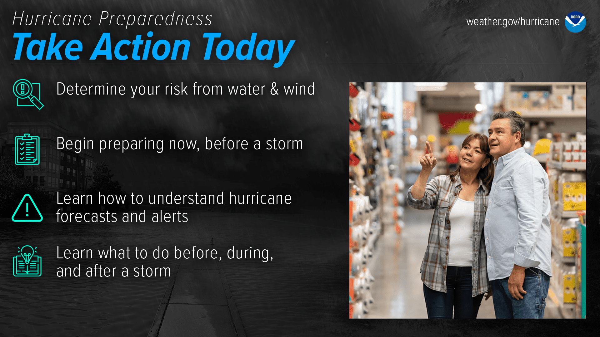
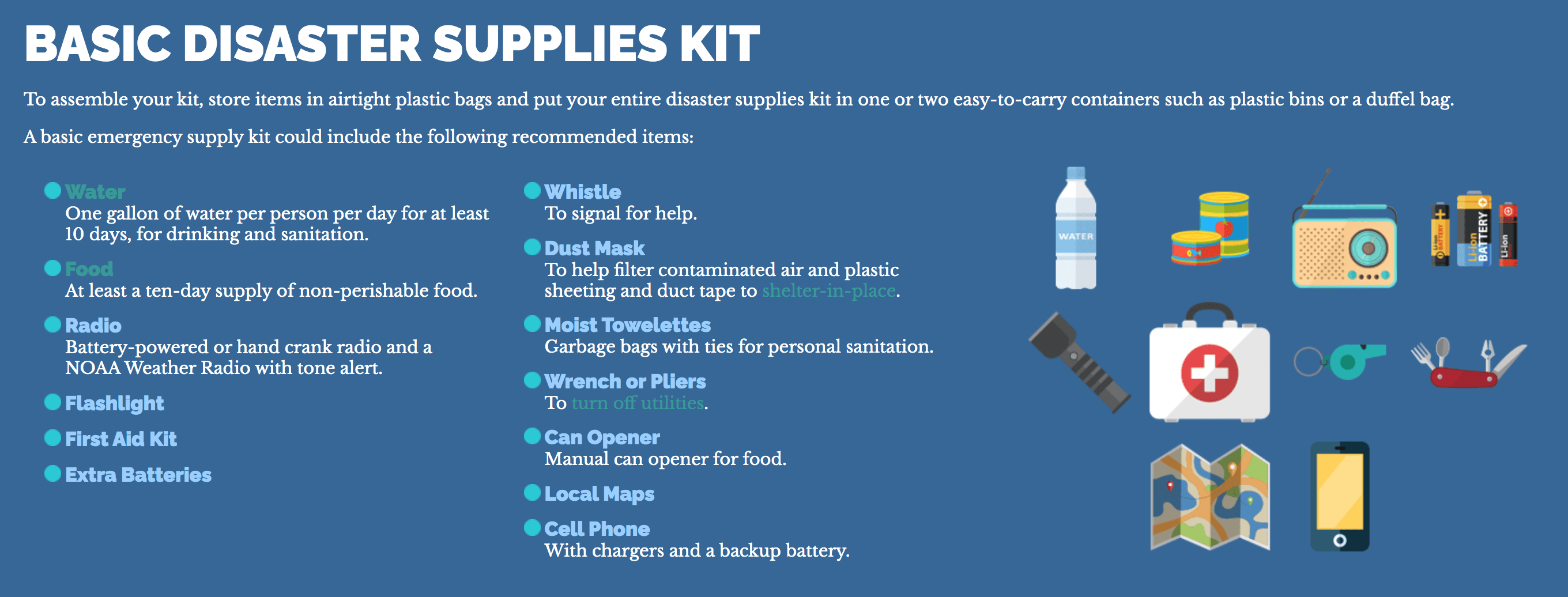
Hurricane Preparedness
Preparedness remains one of the most important tools for saving lives during hurricane season. Even with advances in forecasting, storms can still intensify quickly and catch communities off guard.
Staying ready throughout hurricane season is essential, according to the National Weather Service. (Photo courtesy NWS and NOAA)
As was reported in a previous Source article about the National Oceanic and Atmospheric Administration’s 2025 Atlantic hurricane season forecast, hurricane preparedness was a major topic of discussion. Ken Graham, director of the NWS, urged the public not to focus solely on a hurricane’s category but on the potential impacts. He noted that every Category 5 hurricane that struck the United States in recorded history was classified as a tropical storm or even less intense just three days before landfall as a major hurricane.
“Every Category 5 storm to ever hit this country was a tropical storm or less three days prior,” Graham stressed. “The big ones that hit this country are fast,” he warned.
Beyond the helpful hurricane preparedness tips available from the NHC, Rhome emphasized the importance of preparing for the possibility of extended electrical outages, which can typically occur during a storm and could last for extended periods.
“Power outages are becoming an increasing challenge during and after hurricanes,” Rhome said. “Losing power in the Caribbean during a passing hurricane is certainly not news, but what we’re seeing are more situations happening because of the power outages and dealing with oppressive heat in the days after a hurricane has passed and without air conditioning or fans that rely on power,” Rhome stated.
“We’re seeing more people succumb to heat-related illnesses, including heat stroke,” he acknowledged. “We’re also seeing situations where people are lacking easy access to health care, or the loss of power is making it harder for them to take care of themselves, or they may be utilizing a respirator, or a diabetic individual may need to keep their insulin cool,” he said. “There is a myriad of cascading issues that come from the absence of power, and the NHC encourages individuals to think about what they would do to take care of themselves and their families for not just one day without power, but possibly for a week or even two weeks from a major hurricane.”
Rhome said that one of the most important steps to take to prepare for hurricane season is to assemble an emergency supply kit and take additional preparedness steps, including making a plan for communication with family and friends, particularly if communications are unavailable after a storm.
An emergency supply kit is important to have throughout hurricane season. (Photo courtesy VITEMA)
“Ever since Hurricanes David and Frederic in 1979, when I was in Puerto Rico working on obtaining my master’s degree, I have been a strong believer in preparing if there is the slightest chance of a wobble bringing the storm very near or over us,” Boulon said.
“As that was the case with Erin, I took it seriously and put up shutters on about 90% of my openings, leaving just those that provided some light and air flow and would be easy to close up if necessary. And, as Erin is early in the season, I will likely leave up some of the more difficult shutters to put on,” Boulon explained.
Boulon offered the following words of wisdom for individuals across the USVI as we approach the climatological peak of hurricane season.
“I always recommend to people that they stay vigilant, recognize that storm tracks and intensity can vary drastically sometimes, and always prepare for the worst,” Boulon advised. “More often than not, you will spend a lot of time making unnecessary preparations, but you will never regret having done so if a storm suddenly wobbles into us or goes from a Category 2 to a Category 4 in 12 hours, for example,” Boulon added.
Local Weather Information and Staying Informed
On Monday, the NWS in San Juan reminded individuals about other weather-related threats that will affect the USVI and Puerto Rico over the coming days, including a chance of showers, very warm temperatures with the potential for heat alerts, and an elevated risk of rip currents.
Residents and visitors in the U.S. Virgin Islands and Puerto Rico are encouraged to monitor forecasts on Disturbance #1 in the central Atlantic for possible impacts later this week. (Photo courtesy NHC)
Additionally, a plume of Saharan dust is forecast to arrive Tuesday and will last through Thursday, deteriorating air quality and causing hazy conditions.
It is crucial to remember that the forecast can change very quickly. USVI residents and visitors are encouraged to continue to remain prepared. Weather information is available from the NWS, the NHC, and NOAA.
James Joseph Heying, formerly of Estate Shoys, St. Croix, U.S. Virgin Islands, passed away peacefully surrounded by family this morning, August 15, 2025. Jim was a quiet man with a very loud presence, deeply committed to building a legacy through his children.
Born in Cresco, Iowa, where his family owned and operated a farm, Jim joined the U.S. Army and was stationed in Germany in the late 1970s and early 1980s. Following his service, he attended the University of Iowa, earning both a bachelor’s and master’s degree in accounting before becoming a CPA with Deloitte. He later joined the executive team at the Virgin Islands Telephone Company (VITELCO), where he became a pivotal figure in the company’s leadership.
Jim was deeply engaged in the Virgin Islands community, serving on the Board of Trustees for the Good Hope School and on the Board of the Government Employees’ Retirement System (GERS). He was a member of St. Ann’s Church in Barrenspot, St. Croix, and later St. Thomas More Catholic Church in Coralville, Iowa.
Jim is married to Junia “June” Bideau, and together they raised four very accomplished and self-motivated children: Matthew Heying (Arizona), Nikki Quinn Johnson aka Lexi Jaydon (Texas & Iowa) former Miss Hal Jackson Talented Teen VI 1995 and Miss St.Croix 1996, Christine Heying (Iowa) and Marques Nicholas Brathwaite (U.S. Virgin Islands).
Jim was a devoted grandfather and was actively involved in the lives of his grandchildren—driving them to school, attending countless basketball games, and supporting their academic and personal achievements, including a grandson’s participation in the Disney College Program.
He is preceded in death by his parents Helen and Greg Heying; father-in-law Bruce Williams, affectionately known as “Daddy Bruce,” a prominent political figure in Saint Lucia, particularly in the Vieux Fort region, who served as a Member of Parliament for Vieux Fort South and North and as Minister of Health; uncle, Boswell Williams former Governor-General of Saint Lucia; brother-in-law Cohen Williams; and sister-in-law Carmen Heying, stepfather Zeno Kappes and adoptive parents Ed & Irene Vobr.
Jim’s passing will be felt not only in the U.S. Virgin Islands and the United States, but across Europe, the Caribbean, South America, and South Africa, where his extended family, friends, and professional connections reside.
He is survived by his loving wife, Junia “June” Bideau; his children; his sons-in-law Jerry Johnson and JT Anderson; daughter-in-law Emma Swanson; brothers Louis Heying, Joe (Tara) Heying (Minnesota) and Dean (Joy)Heying; sisters Gail Heying, Colleen Michels, Karen Cook (Colorado), and Elaine (Roland) Fay; stepmother Helen Kappes; Dorothy (Roger) Christensen (Iowa), Duane (Michelle) Kappes (Minnesota) Don (Jodi) Kappes (Iowa) Sharon (Tim) Ryan (Iowa), Steven (Brenda) Kappes (Iowa), Shirley Olson (Minnesota), Suzy (Elvis) Cole (Minnesota), mother-in-law Dorothy “Anza” Bideau; brothers-in-law Peter Bideau, Tenesky Monbelly, Chris Monbelly (Ariela Hayes) Pammar Bideau, Dean Baptiste of Xpress Band, Attorney Michael Joseph, Lincoln Williams; sisters-in-law Kathleen Bideau, Vanda Alezy Baptiste, Carlyn Bideau, Tia Joseph, Ana Monbelly, Wanda Scatliffe, Toye Williams, and Velicia Williams; countless cousins nieces, nephews, grandchildren, and extended family.
Special recognition is given to close family, friends and colleagues- Former Governor of the Virgin Islands Kenneth Mapp, Rudy Abramson, Raymond Abramson, Sylvie Augustin, Yvonne Ramcharitar and family, Marie Samuel and family, Lucia Fredrick and family, Harold Brathwaite and the entire VITELCO family, Marie Bideau and family (New York), Porcia and Sasha Bideau, Kate, Melton, and Richard Adams and family (Virginia), long-time friends Bill and Tuddy Bohlke of Bohlke International Aviation, Earl Morris Sr. (US Virgin Islands), Jathan Desir (Texas), Ty Larson (Arizona), Robby Thorson & Janet Koch( Iowa), John Raynor (Nebraska) and many others who touched Jim’s life.
The family extends heartfelt thanks to the team of amazing doctors at the University of Iowa Cancer Center and the hospice nurses who cared for Jim through the end.
An immediate service and celebration of life will take place in Iowa on Monday August 25, 2025 at St. Thomas More Catholic Church, Coralville, IA at 1:00pm, followed by a gathering at Kent Park in Tiffin, IA. His remains will then be transported to the U.S. Virgin Islands for a final resting place in St.Croix at a later date.
A private memorial and military funeral will be held for friends and family. Memories and condolences may be shared by emailing Nikki Quinn Johnson at nicolejohnson1106@gmail.com
The Virgin Islands Cycling Federation will host the Triple Bypass Road Race this Sunday, Aug. 24 at 7 a.m., starting near the former Milgie’s Convenience store in Sally’s Fancy, on St Croix’s south side.
The race course will include a 15-mile lap, including a climb over the Christiansted Bypass, and will offer three distances: Elite – 45 miles, Expert – 30 miles and Sport/Masters/Women/Juniors – 15 miles.
Race-day registration will be open from 6am to 6:45am. Entry fee: $10 for VICF members, $15 for General. For more information, please contact 340-643-5050.
It is with great sadness that we announce the passing of Courtney Woods Sr., of St. Croix, who died on Aug. 3, 2025. Funeral will be on Friday, Aug. 22 at St. Paul’s Episcopal Church with viewing at 9 a.m. Service to follow at 10 a.m.
The U.S. Virgin Islands Department of Tourism is launching a recruitment drive for local hospitality greeters and entertainers who will welcome visitors at the territory’s airports and cruise ports. The initiative seeks energetic, personable Virgin Islanders who can share the islands’ culture, provide helpful information, and ensure every guest receives a warm introduction to the territory.
A moko jumbie greets guests. (Source photo by Diana Dias)
Department of Tourism Commissioner Nominee Jennifer Matarangas-King highlighted the importance of these roles in delivering an exceptional visitor experience. “Our people are the heart of the U.S. Virgin Islands, and this is an opportunity to showcase that warmth, pride, and hospitality to every guest who steps onto our shores,” she said. “From the very first smile to the moment they begin exploring, these ambassadors will help shape memories that last a lifetime.”
Applicants must be at least 18 years old, have knowledge of the territory, and a passion for hospitality. A flexible schedule, valid business license, and proof of full vaccination are required. Bilingual proficiency in English and Spanish is preferred.
Where to Apply:
Applications are available at the following Department of Tourism offices:
St. Croix: 321 King Street, Frederiksted
St. John: 6A Cruz Bay
St. Thomas: 2318 Kronprindsens Gade
For additional information, contact Director of Administration and Management Jamila Miller Christopher at 340-774-8784 or jmiller@usvitourism.vi.
A 43-year-old man turned himself in to police Sunday after a woman was shot multiple times Saturday night in Frederiksted. (Shutterstock)
A man turned himself in Sunday after a shooting the day before sent a woman to Luis Hospital for emergency surgery, prompting a brief manhunt by the V.I. Police Department. Kenny Rogers, 43, was charged with first-degree attempted murder, first-degree assault and firearms-related crimes.
According to documents filed in V.I. Superior Court, the 911 Emergency Call Center’s ShotSpotter system detected seven gunshots fired late Saturday night on East Street in Frederiksted. Police arrived to find a woman lying on the ground with several gunshot wounds on her back. She was taken to Luis Hospital by ambulance.
An officer spoke with the victim’s brother, who said he heard the woman tell Rogers “that she no longer wanted to be in a relationship with him,” according to the probable cause fact sheet filed in court. The witness said the two argued before Rogers pulled out a gun and shot at them. The woman later also identified Rogers as the shooter.
Police were unable to find Rogers at his New Works home, even after they obtained a search warrant and a tactical unit breached the door. They then issued a wanted poster for Rogers, who surrendered himself later at the Wilbur H. Francis Command. Rogers also surrendered two licensed firearms and declined to give a statement.
Rogers’s bail was set at $100,000 and he was remanded to the John A. Bell Adult Correctional Facility pending an advice of rights hearing scheduled for Monday morning.
The Virgin Islands Water and Power Authority advises the community that restoration efforts are steadily progressing following the impacts of Hurricane Erin.
Downed trees, like the one impacting St. Thomas’ Feeder 6A Sunday, were among the biggest obstacles for WAPA crews working to restore power after Hurricane Erin. (Photo by Ananta Pancham)
In the St. Thomas/St. John district, the Authority began with approximately 21,000 customers without power. Within 24 hours, fewer than 2,000 customers remain out. A small portion of customers on Feeder 7B are still without service, and crews continue to address several isolated outages across St. Thomas. Restoration was initially delayed to allow for necessary repairs to the transmission line, while St. John has been fully restored.
On St. Croix, crews have also made significant progress, reducing the number of customers without service to fewer than 300, down from over 4,000 earlier today. The Authority’s goal is to restore all customers today, as crews continue to work safely and efficiently across the Territory.
As territory-wide restoration continues, customers may experience power restoration with temporary interruptions as the grid stabilizes. If you are still experiencing an outage, please report through the appropriate channels, so crews can be dispatched effectively. Outages may be reported online at https://www.viwapa.vi/customer-service/report-outage-or-problem or by phone at 340-773-2250 or 340-774-5225 – Option 4. For real-time updates, customers may also visit the outage viewer at http://outageviewer.viwapa.vi:7575/.
WAPA thanks the community for their patience and support for the line crews as they continue to work diligently and safely.
Downed trees, like the one impacting St. Thomas’ Feeder 6A Sunday, were among the biggest obstacles for WAPA crews working to restore power after Hurricane Erin. (Photo by Remington Gardner)
Heading into Monday, the Virgin Islands Water and Power Authority was nearing full restoration after Hurricane Erin’s outer bands knocked out electricity to tens of thousands across the territory. The storm passed the USVI at Category 5 strength without making landfall, but driving rain, high winds, and fallen vegetation left widespread outages in its wake.
By Saturday morning, an estimated 14,000 customers in the St. Thomas–St. John district were still without power, with fewer than 4,000 remaining impacted on St. Croix — numbers that significantly exceeded earlier, more modest estimates.Restoration efforts, however, were slow to gain momentum amid hazardous conditions and pressing infrastructure failures.
A critical transmission line that feeds eastern St. Thomas failed Friday afternoon under storm strain, prompting crews to prioritize stabilizing it — work that was essential before any feeder-by-feeder restoration could resume. “Repairs are not fully completed long‑term, but the line is back up now,” said WAPA Communications Director Shanell Petersen in a call with the Source late Sunday afternoon, underscoring that while the line was made operational again, a lasting solution remains in progress. This temporary repair is separate from an ongoing FEMA‑funded Feeder 13 upgrade, part of WAPA’s broader infrastructure hardening strategy.
With conditions improving, crews resumed restoration Saturday, though vegetation continued to pose problems. Fallen and wind-swept branches triggered lingering outages even on otherwise intact feeders. As Petersen explained, “Even as the majority of customers on a particular feeder have been restored, there might still be a few who remain without power,” as even minor contact was enough to trip service.
By Saturday afternoon, partial progress was evident: St. John saw its first sections of power restored, while on St. Croix, crews managed to bring the number of customers without electricity down to fewer than 4,000, largely through reenergizing Feeder 7B and beginning work on Feeder 6A.
Restoration on St. Thomas remained hampered into Saturday evening by ongoing rotating outages. Reports from WAPA cited feeder schedules — with power cycling on Feeder 7B, Feeder 9C and part of 10B, Feeder 7C, and Feeder 9E — as teams secured lines amid challenging conditions.
Meanwhile, rainfall totals confirmed the severity of the storm’s outer bands: about 1 inch on St. Croix, approximately 4 inches on St. Thomas, and up to 6 inches on St. John.
By late Sunday, isolated outages continued to be addressed in neighborhoods across the territory, with WAPA urging residents to report local outages to help crews prioritize dispatch. “Vegetation management continues to pose significant challenges, as anticipated with a storm of this strength,” WAPA stated in a release, naming priority areas like Caret Bay, Contant, and Plantation Manor on St. Thomas, as well as Enighed Hill and Cruz Bay on St. John.
In Erin’s aftermath, WAPA officials stressed that the storm underscored the need to keep strengthening both the grid and the workforce that maintains it. Petersen said the authority deployed all of its restoration crews across both districts once conditions allowed, noting that on St. Croix, cooler weather allowed linemen to work longer hours, while on St. Thomas, extreme heat forced more rotations.
Even with the full force of its workforce in the field, she added, restoration would have been faster with additional resources and personnel. That’s why WAPA has been “aggressively pursuing additional linemen,” reaching out at regional gatherings such as the Caribbean Lineman’s Rodeo and promoting local apprenticeship and internship programs to build capacity at home. Those efforts, she explained, are key to shortening restoration times when widespread outages strike.
At the same time, long-term infrastructure projects are moving ahead. FEMA-backed work to overhaul Feeder 13 — a critical transmission corridor separate from the eastern St. Thomas line that failed during Erin — is underway, part of a larger plan to harden the grid against future storms. Vegetation management will also remain a priority, with Petersen acknowledging that additional resources would allow for more aggressive trimming before winds bring branches down on lines.
Despite the challenges, Petersen said Erin showed clear signs of progress. “We were in a much better place than we were last year,” she said, recalling how long it took to bring the system back after Tropical Storm Ernesto in 2024. By early Monday, she said, all feeders were expected to be back on, with the remaining outages limited to isolated pockets scattered across neighborhoods.
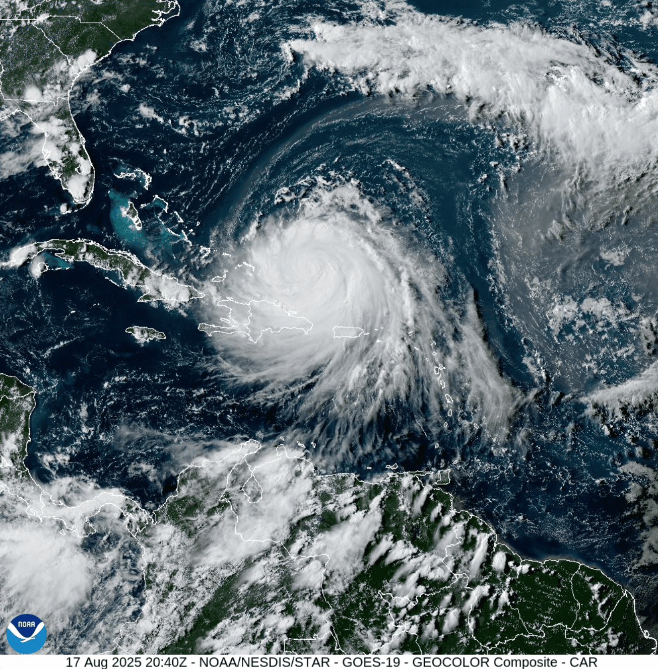
Hurricane Erin moved farther north into the Atlantic Sunday after brushing past the U.S. Virgin Islands and Puerto Rico with gusty winds, rain and rough surf. Several severe weather alerts remain in effect through Monday as outer rainbands continue to impact the region.
Hurricane Erin underwent extreme rapid intensification over the weekend, strengthening from a Category 1 storm Friday morning to a Category 5 hurricane in just 24 hours. By Sunday afternoon, the system had weakened to a Category 3, but forecasters say it is expected to re-intensify and grow in size as it approaches the Turks and Caicos and the Bahamas.
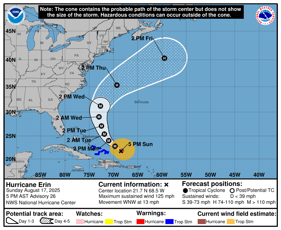
Track of Hurricane Erin
As of the 5 p.m. Sunday update from the NHC, Hurricane Erin was located about 275 miles northwest of San Juan, Puerto Rico, moving west-northwest with maximum sustained winds of 125 mph. The storm’s minimum central pressure was measured at 946 millibars.
Hurricane Erin’s projected storm track as of 5 p.m. on Sunday. The storm continues to move away from the USVI and Puerto Rico. (Photo courtesy NHC)
“At 5:00 p.m. AST, the center of Hurricane Erin was located near latitude 21.7 North, longitude 68.5 West. Erin is moving toward the west-northwest near 13 mph. This general motion is expected today, followed by a gradual turn to the northwest and north on Monday and Tuesday. On the forecast track, the core of Erin is expected to pass to the east and northeast of the Turks and Caicos Islands and the southeastern Bahamas tonight and Monday,” the NWS said.
“Maximum sustained winds are near 125 mph with higher gusts. Erin is a Category 3 hurricane on the Saffir-Simpson Hurricane Wind Scale. Some increase in size and strength is forecast during the next 48 hours. Erin is likely to remain a dangerous major hurricane through the middle of this week,” according to the NWS.
Impacts Across USVI
The core of Hurricane Erin passed just north of the U.S. Virgin Islands Saturday as a major hurricane. While the center remained north of the local islands, the storm tracked slightly farther south and west than earlier forecasts had predicted. Erin moved close enough to bring tropical-storm-force wind gusts at times and heavy rainfall to areas across the region.
Visible satellite imagery obtained at 4:40 p.m. on Sunday as the system continued to move west-northwest and away from the USVI and Puerto Rico. (Photo courtesy NOAA)
Other severe weather alerts included a Flood Watch, High Surf Advisory, High Rip Current Risk and Small Craft Advisory for both Puerto Rico and the U.S. Virgin Islands. These alerts will remain in effect until Monday.
On Sunday, the Source spoke with Daryl Jaschen, director of the Virgin Islands Territorial Emergency Management Agency, about storm-related impacts in the U.S. Virgin Islands following preliminary assessments across the territory.
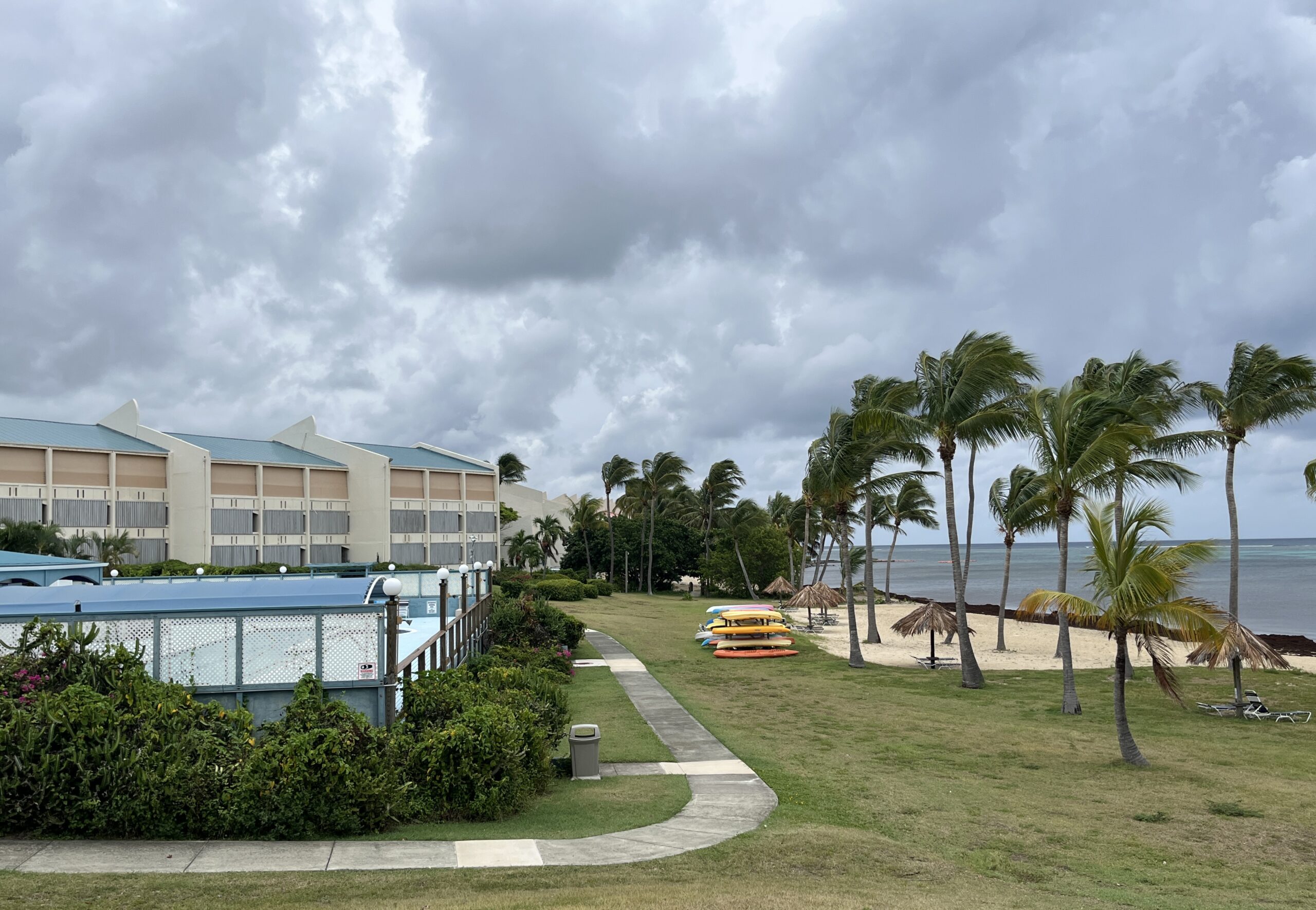
Storm shutters remained closed on the Northside of St. Croix on Sunday as gusty winds continued to affect the island. (Source photo by Jesse Daley)
Jaschen said that as of Sunday afternoon, power outages were ongoing on St. Thomas, St. John and St. Croix, with St. Thomas experiencing the most widespread disruptions. However, officials with the Virgin Islands Water and Power Authority were confident that most feeders would be restored Sunday night.
A palm tree on St. Thomas swayed as the winds picked up Saturday when Hurricane Erin passed by the U.S. Virgin Islands. (Source photo by Michele L Weichman)
Across the islands, fallen branches were reported, but few trees were downed.
Jaschen also reported that several boats had sunk across the territory. According to information posted online, an iconic pirate ship docked in Charlotte Amalie Harbor was among the ships that sank during the storm.
Wind and Rainfall Details
Speaking to the gusty conditions, Jaschen said tropical storm-force winds extended about 160 miles from the center of Hurricane Erin. However, the strongest winds were concentrated in the storm’s northeastern quadrant and farther away from the U.S. Virgin Islands.
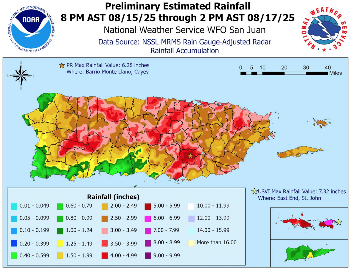
Preliminary rainfall estimates associated with Hurricane Erin as of Sunday afternoon. (Photo courtesy NWS)
Still, Jaschen noted that multiple rainbands swept across the islands, and some produced gusts that reached tropical-storm strength.
Regarding rainfall totals, Jaschen explained that, according to the National Weather Service in San Juan, Puerto Rico, the British Virgin Islands received approximately 10 inches of rain, St. Thomas received about four inches, and St. John collected roughly six inches. St. Croix — located farther south of Erin’s core — received approximately one inch of rain.
The Source also connected with Rafe Boulon, a weather observer on St. John, who meticulously records rainfall data from his home at Trunk Bay. Boulon told the Source that he measured over four inches of rain as of Sunday afternoon.
“I recorded 4.43 inches of rain over the two days of the storm,” Boulon said.
Boulon also noted that the south side of St. John was more significantly affected than the northern-facing portions of the island.
“Winds were pretty light on the north side of St. John,” Boulon explained. “South-facing homes were hit harder with the stronger backside, south to southwest winds. We were very lucky that Erin passed far enough to our north that we were spared any significant damage,” Boulon said.
Jaschen said that as of Sunday evening, government offices and schools would be open on Monday. However, several schools may have a delayed start, and announcements would be provided if any changes are expected.
Finally, according to information available online, seaports in the USVI are open, and airports across the territory are operational. However, travelers are advised to check directly with their airlines for the latest updates on potential delays or cancellations.
National Weather Service Information
The NWS in San Juan reminded residents and visitors that the local islands may still receive some impacts over the next day or so as Erin pulls farther away from the USVI. The NWS shared the following information Saturday regarding continuing impacts from Erin.
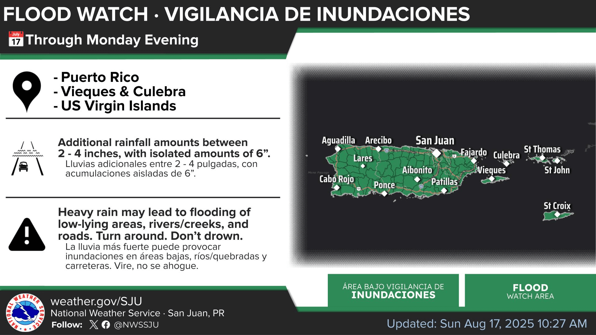
“Although the system continues its route to the Western Atlantic, associated feeder bands are expected to move over the U.S. Virgin Islands and eastern sections of Puerto Rico this evening and into the late-night hours,” the NWS said. “The strongest showers will continue to result in low-level flooding, including at low-lying river crossings and in small urban streams. Winds will become more southerly as the system moves north. Given the expected conditions, a Flash Flood Watch remains in effect until Monday evening,” the NWS explained.
A Flood Watch will remain in effect across the region until Monday. (Photo courtesy NWS)
The NWS added that weather conditions on Monday would likely be cloudy with additional rainfall, with a continued chance of flooding. Weather conditions are expected to improve on Tuesday, though very warm temperatures will affect the islands.
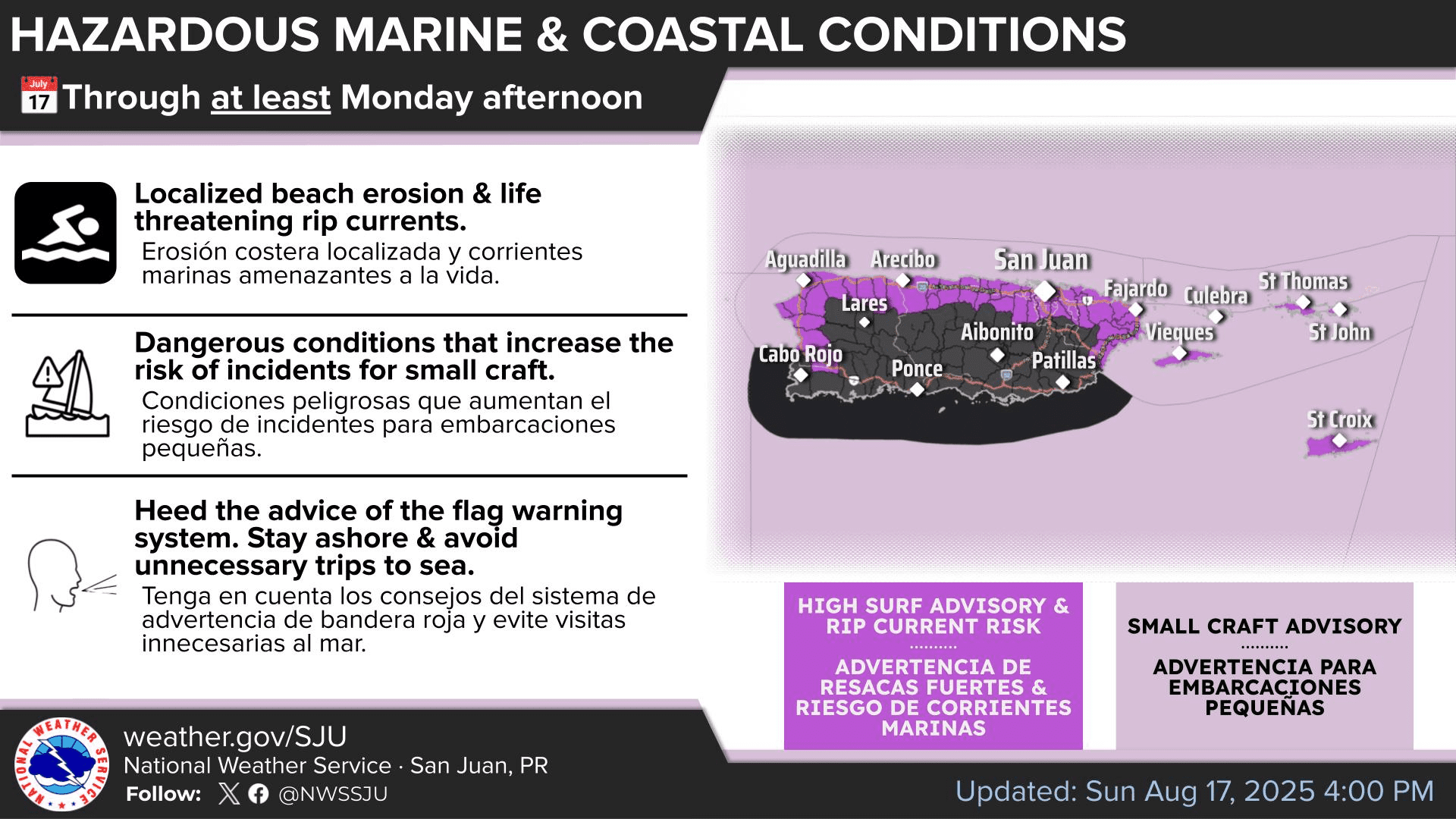
The NWS also urged caution regarding hazardous marine conditions, noting that seas will continue to be rough for the next few days, and there will continue to be an elevated risk of rip currents.
Marine conditions will remain hazardous across the USVI and Puerto Rico. (Photo courtesy NWS)
Looking Ahead
In addition to tracking Hurricane Erin, the NHC was monitoring two other areas across the Atlantic basin on Sunday afternoon. One disturbance was located off the east coast of the U.S. mainland, while another tropical wave was moving across the central Atlantic.
Individuals in the USVI and Puerto Rico are encouraged to closely monitor the progress of the tropical wave in the central Atlantic for any potential future impacts.