

A slight increase in moisture may bring scattered showers to Puerto Rico and the U.S. Virgin Islands, while forecasters at the National Hurricane Center monitor two areas with low chances of tropical development across the Atlantic basin. Neither currently poses an immediate threat to the northeastern Caribbean.
Sporadic Increase in Showers
On Thursday, the National Weather Service in San Juan, Puerto Rico, said moisture and instability are expected to increase across Puerto Rico and the U.S. Virgin Islands through Friday, bringing the potential for some much-needed precipitation. Still, the NWS does not anticipate significant amounts of rainfall.
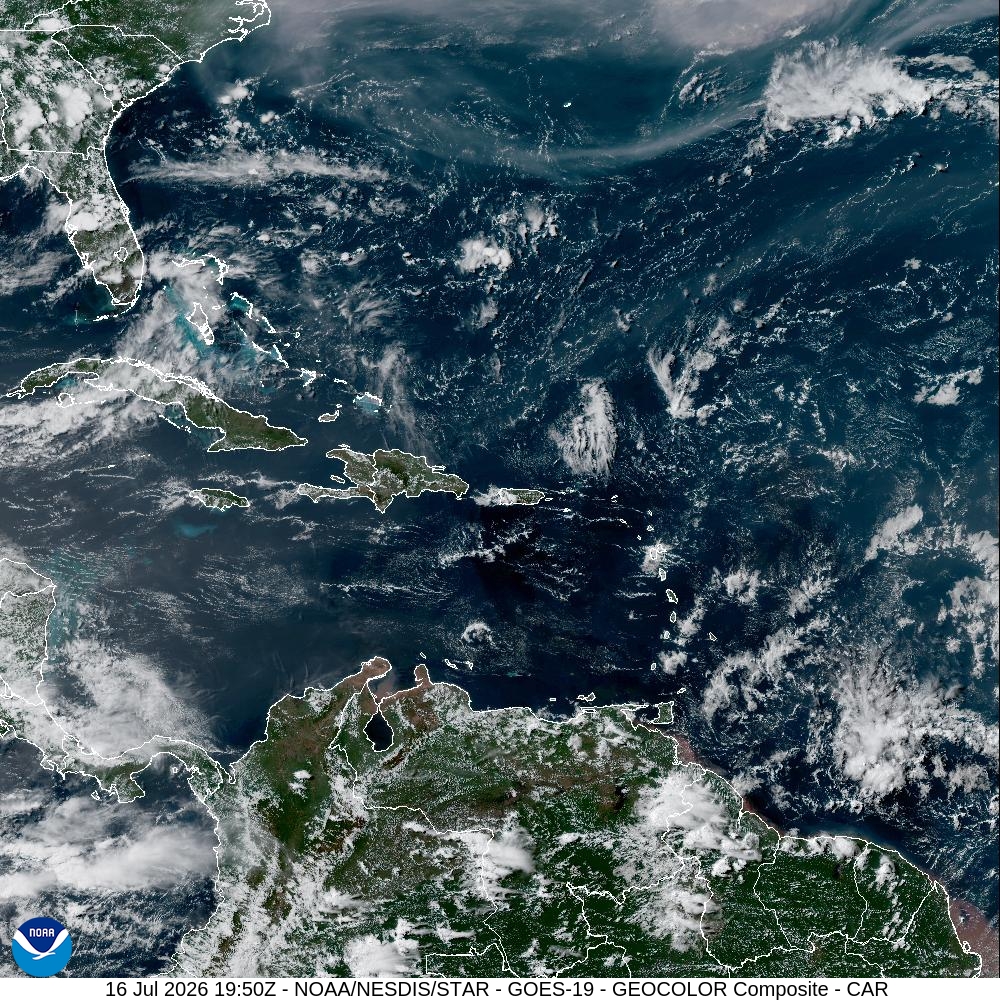
“An increase in moisture will bring a higher chance of showers and a few thunderstorms on Thursday and Friday, mainly across the interior and western portions of Puerto Rico during the afternoon. Localized ponding of water on roads and in poor drainage areas is possible, but widespread flooding is not expected.”
Hot and humid conditions will continue, along with an elevated heat index. Saharan dust has temporarily decreased, but another plume may arrive around Sunday and Monday. The NWS also noted that another chance of precipitation may occur next week.
NHC Monitors Eastern Atlantic Wave
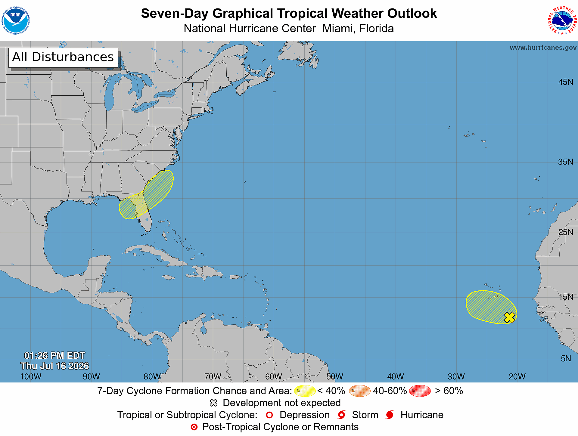
The NHC is monitoring two areas across the Atlantic basin for possible cyclonic development, including a tropical wave southeast of the Cabo Verde Islands off the west coast of Africa. As of Thursday morning, the disturbance had a 10% chance of development through both 48 hours and seven days.
The Source contacted Alex DaSilva, lead hurricane expert at AccuWeather, for more details. DaSilva explained that the tropical wave has only a very brief opportunity to organize.
“We are forecasting a low risk of tropical development near the Cabo Verde Islands from July 16-18,” DaSilva said. By Sunday, the wave is expected to encounter stronger wind shear and dry air.
Wave Expected to Pass North of Local Islands
The eastern Atlantic tropical wave remains thousands of miles east of Puerto Rico and the USVI. DaSilva said current projections take it north of the local islands, although some moisture could still reach the region.
“It looks like the wave will pass to the north of the islands,” DaSilva stated. “However, it may still pass close enough where there can be a few showers with it. There is a lot of dry air and dust across the basin, which should limit heavy rainfall,” he continued.
The system remains several days away, and residents should continue following official forecasts as it moves westward.
Possible Development Near Southeast United States
The NHC is also monitoring the potential formation of a low-pressure system over the northeastern Gulf region. Gradual development may be possible as it moves toward the southeastern United States early next week.
DaSilva said AccuWeather forecasters continue to identify a low chance of tropical development in the northeastern Gulf or just offshore of the Southeast coast from July 19 through July 21.
“If anything develops in the Gulf, the storm will likely move into the Florida Panhandle or the Big Bend area of Florida, bringing the chance for flooding rain across portions of the southeastern United States,” DaSilva reported.
El Niño Suppressing Atlantic Development
DaSilva said AccuWeather recently lowered its Atlantic named-storm forecast, largely because of the strengthening El Niño pattern.
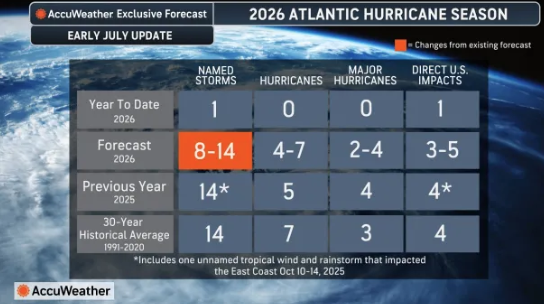
“El Niño continues to strengthen,” DaSilva confirmed. “Right now, I would say we are in a moderate El Niño, and we have about a 70% chance of getting to Super El Niño by the end of the hurricane season.”
El Niño can increase upper-level winds and wind shear across the Atlantic, making it more difficult for tropical cyclones to organize.
“The wind shear is already higher than average across the basin, especially in the Caribbean, where it is very high,” DaSilva said. “This wind shear and dry air will help to suppress development.”
NOAA Outlook Highlights Wind Shear Across Atlantic
NOAA’s Climate Prediction Center offered additional context in its latest Global Tropics Hazards Outlook, released Tuesday and valid from July 22 through Aug. 4.
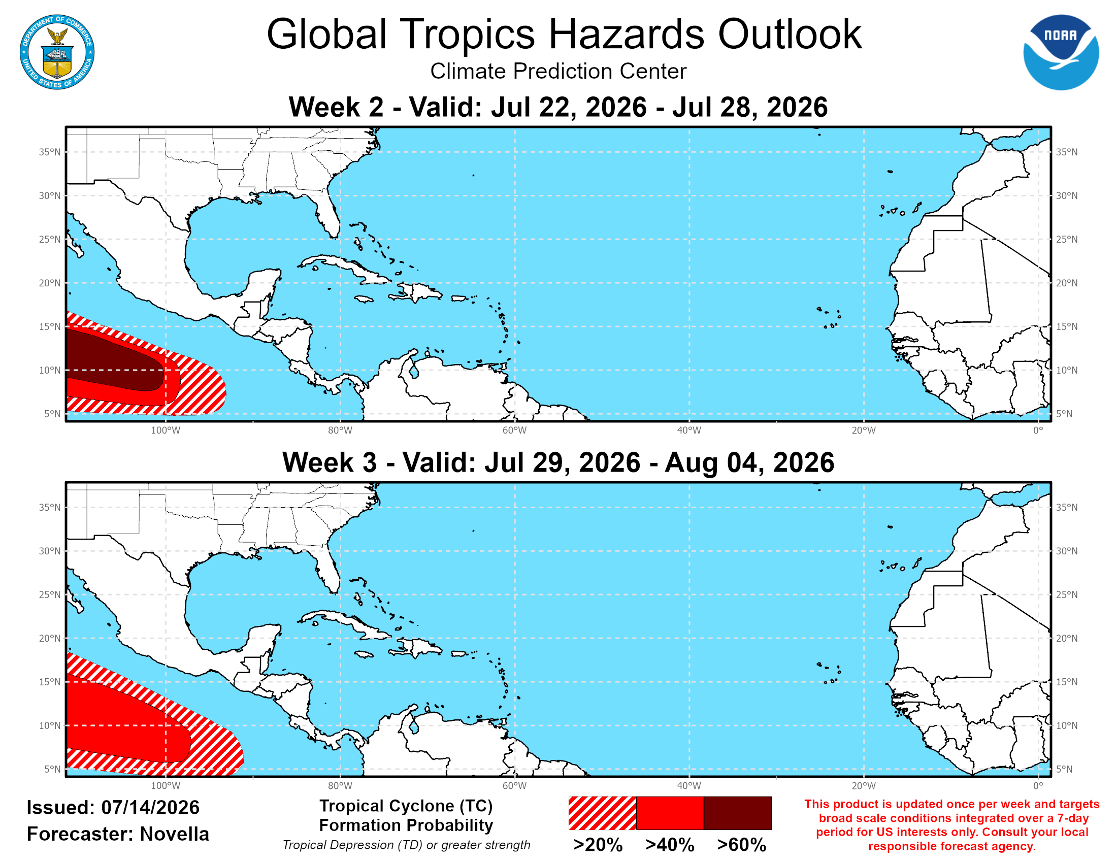
The outlook said the chances of tropical cyclone formation across the Caribbean and tropical Atlantic have increased compared with previous forecasts. However, confidence remains low because the ongoing El Niño continues to contribute to a generally hostile environment for development across the basin.
Despite the comparatively improved chances, the CPC said “no tropical cyclone areas are posted for the Caribbean and tropical Atlantic” during the two-week outlook period. Much of the basin is also favored to receive below-normal rainfall.
Additional tropical waves are expected to continue moving off the coast of Africa. The CPC noted that any development would most likely occur in the far eastern Main Development Region before the waves encounter a strong zone of wind shear extending from the Caribbean into the central tropical Atlantic.
That zone of stronger shear is expected to persist through early August. Lower wind shear may provide occasional opportunities for development over the Gulf and subtropical Atlantic, although the CPC cautioned that these higher-latitude disturbances remain difficult to predict at extended time ranges.
The outlook continues to favor tropical cyclone development across both the eastern and western Pacific during the next several weeks, with the highest probabilities focused on the eastern Pacific.
Active Pacific Expected to Continue
DaSilva said El Niño is contributing to the striking difference between the relatively quiet Atlantic and the much busier Pacific basins.
“There is a strong correlation between El Niño and a more active Pacific basin,” he said. “This goes for both the eastern Pacific and the western Pacific. We continue to expect an active season in the Pacific.”
He said AccuWeather is watching for possible impacts near Hawaii and Southern California later in the season.
“We are concerned about Hawaii this year, as well as Southern California, for the potential of impacts,” DaSilva said. “Sea-surface temperatures are warmer this year than they were when Hurricane Hilary moved toward Southern California.”
Quiet Pattern Expected Near Caribbean
Looking ahead, DaSilva said the Atlantic should remain fairly quiet during the next several weeks, particularly around Puerto Rico and the USVI.
“Overall, the Atlantic looks relatively quiet over the next few weeks, especially as it relates to impacts to the islands,” DaSilva predicted. “Strong wind shear and dry air should prevent much from moving toward the islands.”
Any near-term development would most likely occur closer to the continental United States, he added.
Gusty trade winds will continue to produce locally choppy marine conditions. A moderate risk of rip currents may develop around portions of Puerto Rico and the USVI over the coming days.
Local Updates
Neither area currently monitored by the NHC represents an immediate tropical cyclone threat to Puerto Rico or the U.S. Virgin Islands. However, residents and visitors across the islands are encouraged to continue monitoring updates throughout the hurricane season.
Information regarding the weather across the USVI is available from the NWS, the NHC, and NOAA. Additionally, the local forecast is regularly updated on the Source Weather Page, and a weekly video forecast is available.
Residents and visitors can also view weather alerts and disaster preparedness information from the Virgin Islands Territorial Emergency Management Agency.