Wind shear is a weather term often used during hurricane season, but it can sometimes sound like technical jargon. For residents in the U.S. Virgin Islands and across the Caribbean, understanding what wind shear means can help explain why some tropical waves struggle to develop, while others can organize when conditions are favorable.
Understanding Wind Shear
In simple terms, wind shear refers to a change in wind speed or direction with height in the atmosphere. During hurricane season, meteorologists talk about vertical wind shear, or how winds change from the lower part of the atmosphere to the upper levels.
“Wind shear is the variation of the wind’s speed or direction over a short distance within the atmosphere,” according to information from the National Oceanic and Atmospheric Administration’s Atlantic Oceanographic and Meteorological Laboratory. “For tropical cyclones, wind shear is important primarily in the vertical direction, as these storms occupy a large vertical slice of the atmosphere from sea level to the top of the troposphere, which extends up to about 40,000 feet altitude in the tropics in summer,” NOAA said.
How Wind Shear Can Disrupt Tropical Systems
NOAA explained in further detail how wind shear can affect tropical storms and hurricanes:
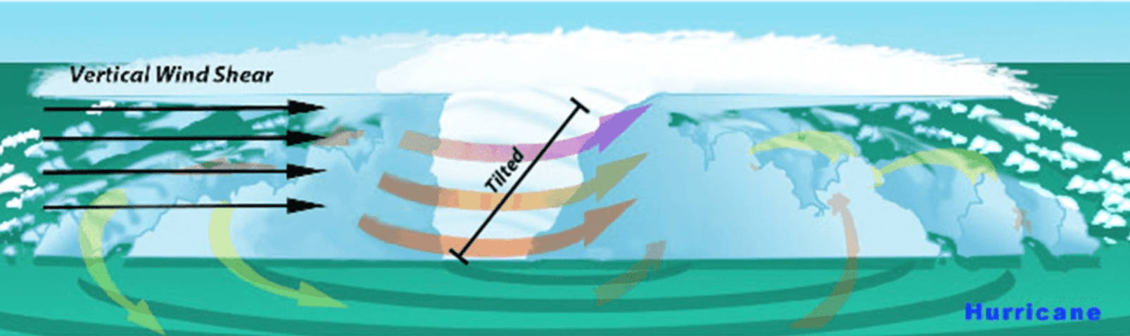
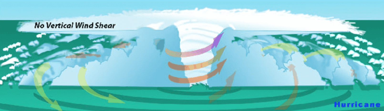
“Tropical weather systems are vulnerable to changes in the broader atmosphere surrounding them, often influenced by large features such as areas of high and low pressure and fronts. If there’s too much wind, these weather systems have trouble organizing and developing into a tropical cyclone. As a tropical system forms, heavy thunderstorms build near the center. Given the right environment, these systems can eventually begin turning counter-clockwise, or cyclonically, in the northern hemisphere. With little to no wind shear, the turning within the tropical system is uniform and the storm becomes vertically aligned, helping to keep it intact and likely strengthening.”
“The most favorable condition for tropical cyclone development is the absence of wind shear. When wind shear is present, however, a storm’s core structure becomes vertically tilted in relationship to the wind shear, disrupting the flow of heat and moisture. Tropical cyclones are heat engines powered by the massive heat release associated with water vapor condensing into liquid water. Vertically-tilted systems are less efficient at drawing in warm and moist air from the surrounding ocean and will be less likely to develop and strengthen,” NOAA stated.
The National Hurricane Center’s Mariner’s Tropical Cyclone Guide lists low vertical wind shear as one of the key ingredients for tropical cyclone development, describing it as, “Little change in wind speed or direction throughout the depth of the troposphere.”
Notably, wind shear does not necessarily mean residents will feel stronger winds at the surface. Breezy conditions across the Virgin Islands are more often tied to trade winds, pressure patterns, passing tropical waves, or local weather features.
The El Niño Connection
The latest El Niño update adds a timely reason to explain wind shear this season. The NOAA’s Climate Prediction Center issued an El Niño Advisory on Thursday, June 11, stating that El Niño conditions are now occurring.
“El Niño conditions are present and expected to strengthen into the Northern Hemisphere winter 2026-2027,” the CPC said.
The CPC noted that above-average sea surface temperatures have developed across the central and eastern equatorial Pacific Ocean, and that there is a 63% chance of a very strong El Niño during the November-January period.
That matters for hurricane season, because El Niño often increases wind shear across parts of the Atlantic basin, including the Caribbean, while reducing wind shear in parts of the Pacific. NOAA/AOML explains that during El Niño, changes in the jet stream can lead to decreased wind shear in the Pacific and increased wind shear across much of the Caribbean and Atlantic.
A Weather Expert’s Perspective
The Source contacted Alex DaSilva, AccuWeather’s lead hurricane expert, to obtain additional information about wind shear, and why it is expected to play a major role this season.
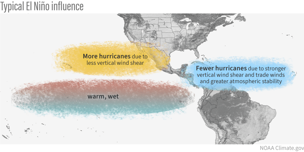
“El Niño typically leads to fewer storms in the Atlantic, because it increases wind shear, creating hostile upper-level winds that disrupt tropical development,” DaSilva said. “That tends to keep storm numbers lower overall, with more frequent periods of wind shear across the Atlantic basin. It’s the opposite in the Pacific. During El Niño years, there is generally less wind shear, which allows for more active hurricane seasons there,” DaSilva explained.
“Overall, during this hurricane season, wind shear is expected to be higher across the Atlantic, which should limit development for much of the season. However, it will not be constant. There will still be periods of lower wind shear, and those are the windows when powerful storms can form, especially with very warm ocean temperatures. The stronger El Niño becomes, the lower the total number of storms is likely to be. If we reach a ‘Super El Niño,’ storm totals would likely fall toward the lower end of the forecast range,” DaSilva said.
That combination of higher wind shear overall and very warm ocean water in parts of the basin, is one reason forecasters continue to stress preparedness.
“I am still concerned about the risks this season. Ocean temperatures are expected to be extremely warm, and ocean heat content will be very high. Any storm that finds a pocket of lower wind shear could rapidly intensify. That’s the risk this year. People may see a season with fewer storms and assume there is little to worry about. But that can actually make it more dangerous, because people may let their guard down,” DaSilva cautioned.
Wind Shear Does Not Eliminate Development Risk
Indeed, wind shear also is not the only factor that determines whether a tropical system develops. Warm ocean water, ocean heat content, moisture, dry air, Saharan dust, tropical waves and steering patterns are all examples of components that can contribute to the development of a storm.
As the Source reported recently, the Atlantic basin remains relatively quiet overall, although there is a slight chance for development in the Gulf region.
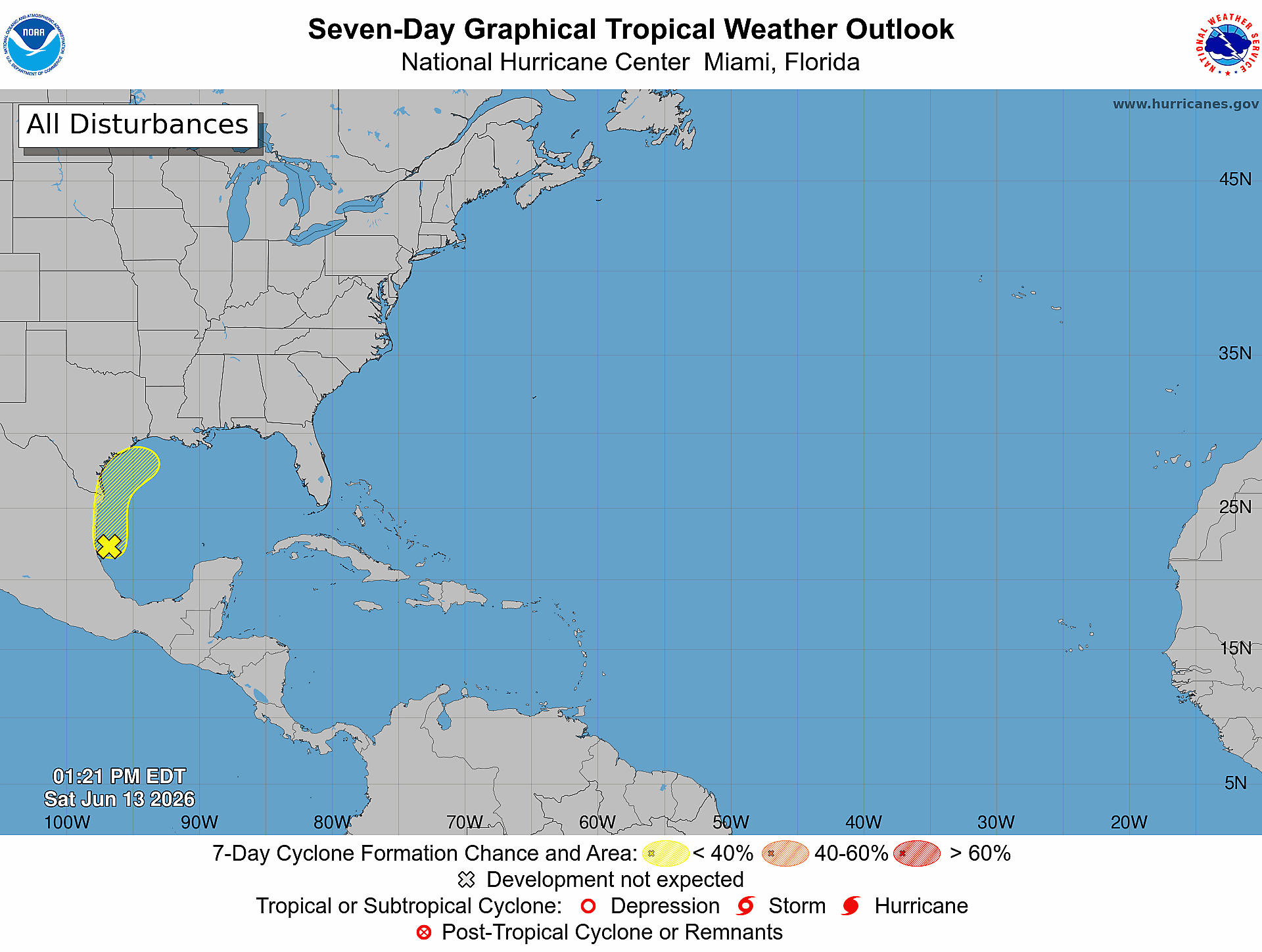
As of Saturday afternoon, the NHC said a broad area of low pressure just offshore of eastern Mexico was producing disorganized showers and thunderstorms in the southwestern Gulf. Significant development is not expected before the system moves inland over eastern Mexico by early Sunday. The NHC gave the system a low, 10% chance of formation through 48 hours and a low, 20% chance through seven days.
The NHC added that the system could re-emerge over the northwestern Gulf on Tuesday or Wednesday while interacting with a frontal boundary, although conditions there are expected to be only slightly conducive for development.
In the eastern Pacific, the NHC is monitoring a trough of low pressure located southwest of the Baja California Peninsula. Significant development is not expected, and the system has a low, 10% chance of formation through 48 hours and seven days. Tropical cyclone formation is not expected in the central North Pacific during the next seven days.
Still, the Pacific has already shown early-season activity, and NOAA’s CPC has indicated that conditions may become highly favorable for additional East Pacific tropical cyclone development later in June.
Forecast Updates
DaSilva said that Caribbean residents and visitors should remain aware as the season progresses.
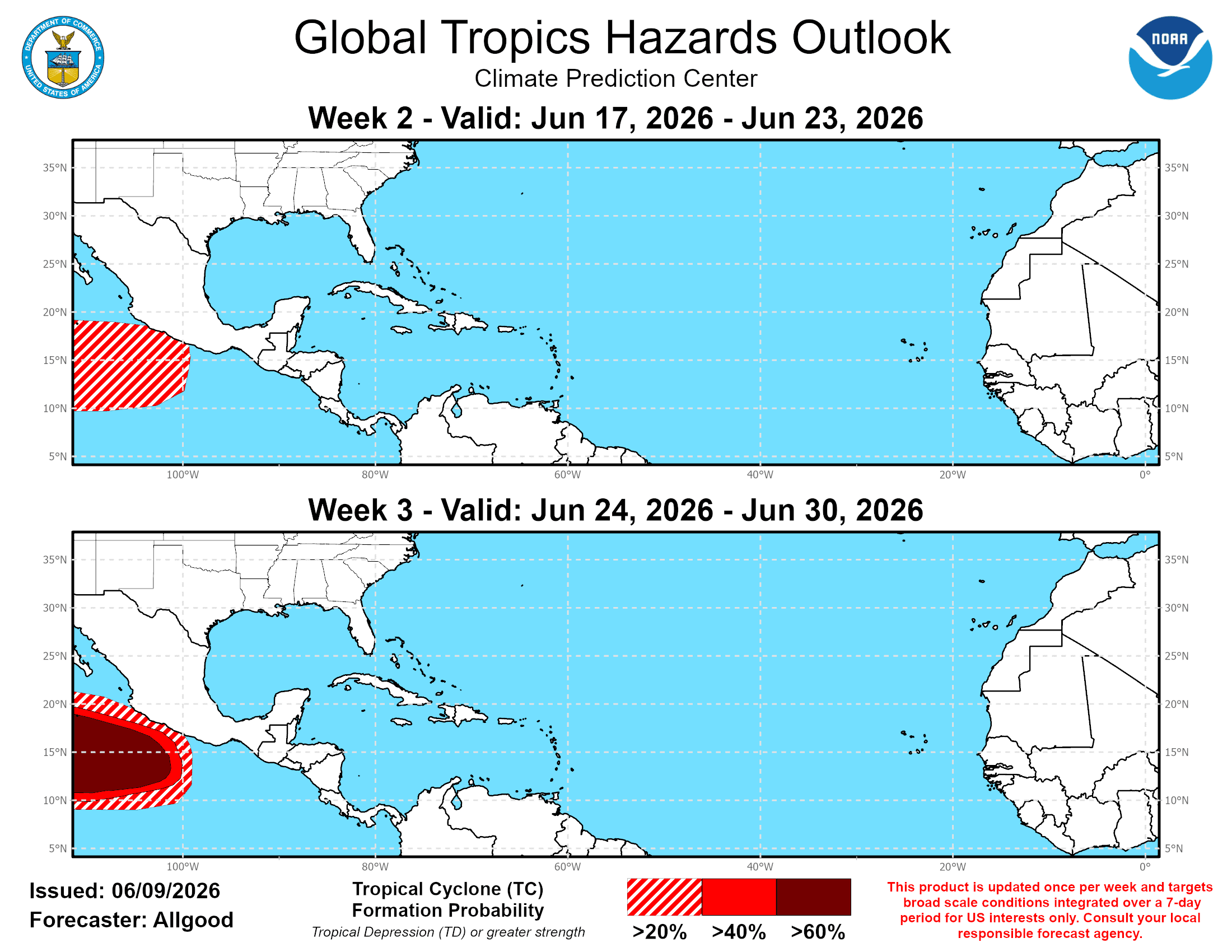
“For the Caribbean, especially the eastern Caribbean, the higher risk typically comes later, usually starting in July and increasing into August. Early in the season, it is more common to see tropical waves that have not fully developed yet. If El Niño becomes very strong, especially a super El Niño, wind shear would likely be stronger during the second half of the hurricane season,” DaSilva noted.
Information regarding the weather across the USVI, including marine forecasts, is available from the NWS and NOAA. The latest tropical forecasts can be viewed on the official website of the NHC.
The local forecast is regularly updated on the Source Weather Page, and a weekly video forecast is available. Additionally, residents and visitors can view weather alerts and disaster preparedness information from the Virgin Islands Territorial Emergency Management Agency

