Early Notice and Public Review of a Proposed Activity in a Designated Floodplain
June 29, 2026
To: All Interested Agencies, Including the U.S. Army Corps of Engineers, Federal Emergency Management Agency (FEMA), Office of the Governor, U.S. Environmental Protection Agency Region II, National Oceanic and Atmospheric Administration (NOAA),
U.S. Fish and Wildlife Service, Virgin Islands Department of Planning and Natural Resources, Virgin Islands Territorial Emergency Management Agency, Virgin Islands Department of Public Works, Virgin Islands Economic Development Authority, Virgin Islands Port Authority, and all interested groups and individuals.
This is to give notice that the Virgin Islands Housing Finance Authority (VIHFA), as the Responsible Entity under 24 CFR Part 58, has determined that the following proposed action under the Community Development Block Grant–Mitigation (CDBG-MIT) Program, Grant No. B-18-DP-78-0002, is located in a floodplain, and VIHFA will be identifying and evaluating practicable alternatives to locating the action within the floodplain and the potential impacts on the floodplain from the proposed action, as required by Executive Order 11988, as amended by Executive Order 13690, in accordance with HUD regulations at 24 CFR 55.20, Subpart C, Procedures for Making Determinations on Floodplain Management and Protection of Wetlands.
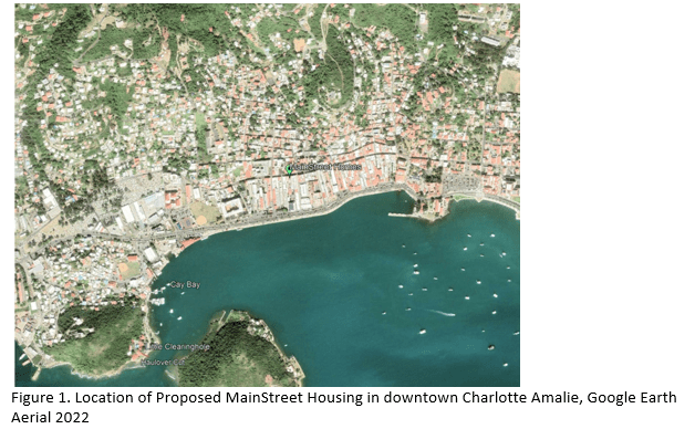
The proposed Main Street Homes project is located at 80 Kronprindsens Gade, Charlotte Amalie, St. Thomas, U.S. Virgin Islands. The project involves the rehabilitation of a historic three-story building into nine (9) residential rental apartments. The historic structure sustained significant damage during Hurricanes Irma and Maria in 2017, including extensive damage to the roof and interior portions of the building. Although the building remains structurally intact, substantial rehabilitation is required to restore the structure for residential occupancy. The building previously contained residential units and retail space fronting Main Street.
The three-story structure consists of approximately 2,000 square feet on each floor, for a total of approximately 6,000 square feet. Upon completion, the building will contain nine (9) residential rental units, including one ADA-accessible apartment on the first floor. Each unit will include a bathroom, kitchen, and living area. The first floor will contain three studio apartments and a common laundry area with two washers and two dryers. The second floor will contain one one-bedroom apartment and two studio apartments. The third floor will contain two two-bedroom apartments and one studio apartment. Rehabilitation activities will occur within the existing building footprint and on the existing structure. No excavation, filling, grading, or other ground-disturbing activities are proposed. Solar panels will be installed on the existing roof to offset energy costs.
The apartments are designed to accommodate up to nine (9) families. The development is intended to increase the availability of resilient, hurricane-resistant, affordable rental
housing for residents of the U.S. Virgin Islands and will serve low- to moderate-income (LMI) households consistent with CDBG-MIT program objectives.
The project site is located along Main Street within the historic district of Charlotte Amalie. The subject building, constructed in 1848, is a three-story brick structure situated along Dronningsens Gade (Main Street). The building is U-shaped and contains a historic well within the interior courtyard.
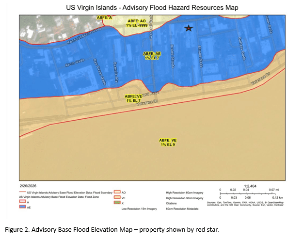
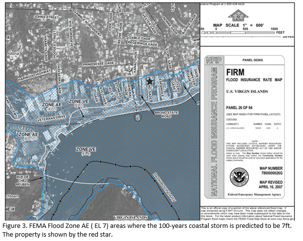
The area has been extensively altered from its historic condition and is fully developed. The property is relatively level and is located at an elevation of less than 10 feet above mean sea level near Main Street. The USDA Custom Soil Survey identifies the site as Urban Land (UbD), indicating that the area has been significantly modified and no longer retains its original soil characteristics. The property is located within FEMA Flood Zone AE, where the base flood elevation has been established at 7 feet according to FEMA Flood Insurance Rate Map (FIRM) Panel 26 of 94.
The property is fully developed and no filling, excavation, or earthwork activities are proposed. Existing finished floor elevations are approximately 9.5 feet above mean sea level, which exceeds the established base flood elevation of 7 feet.
There are three primary purposes for this notice. First, people who may be affected by activities in the floodplain and those who have an interest in the protection of the natural environment should be given an opportunity to express their concerns and provide information about this area. Commenters are encouraged to offer alternative sites outside of the floodplain, alternative methods to serve the same project purpose, and methods to minimize and mitigate project impacts on the floodplain. Second, an adequate public notice program can be an important public educational tool. The dissemination of information and request for public comment about the floodplain can facilitate and enhance Federal efforts to reduce the risks and impacts associated with the occupancy and modification of these special areas. Third, as a matter of fairness, when the Federal government determines it will participate in actions taking place in the floodplain, it must inform those who may be put at greater or continued risk.
Written comments must be received by VIHFA at the following address on or before July 14, 2026: VIHFA Virgin Islands Housing Finance Authority, 3202 Demarara Plaza, Suite 200, St. Thomas, VI, 00802-6447 and (340) 777-4432, Attention: Ms. Dayna Clendinen, Chief Disaster Recovery Officer, during the hours of 9:00 AM to 5:00 PM. Comments may also be submitted via email at media@vihfa.gov.
Regards,
Dayna Clendinen
Digitally signed by Dayna Clendinen
Date: 2026.06.24 23:32:28 -04’00’
Chief Operating Officer
Chief Disaster Recovery Officer
Virgin Islands Housing Finance Authority
Aviso Temprano y Revisión Pública
de una Actividad Propuesta en una Llanura de Inundación Designada
29 de junio de 2026
Para: Todas las agencias interesadas, incluyendo el Cuerpo de Ingenieros del Ejército de los Estados Unidos (U.S. Army Corps of Engineers), la Agencia Federal para el Manejo de Emergencias (FEMA), la Oficina del Gobernador, la Agencia de Protección Ambiental de los Estados Unidos, Región II (EPA), la Administración Nacional Oceánica y Atmosférica (NOAA), el Servicio de Pesca y Vida Silvestre de los Estados Unidos (U.S. Fish and Wildlife Service), el Departamento de Planificación y Recursos Naturales de las Islas Vírgenes, la Agencia Territorial para el Manejo de Emergencias de las Islas Vírgenes, el Departamento de Obras Públicas de las Islas Vírgenes, la Autoridad de Desarrollo Económico de las Islas Vírgenes, la Autoridad Portuaria de las Islas Vírgenes, así como todos los grupos e individuos interesados.
Por medio de la presente se notifica que la Autoridad de Financiamiento para la Vivienda de las Islas Vírgenes (VIHFA), en calidad de Entidad Responsable conforme a 24 CFR Parte 58, ha determinado que la siguiente acción propuesta bajo el Programa de Subvención en Bloque para el Desarrollo Comunitario–Mitigación (CDBG-MIT), Subvención No. B-18-DP-78-0002, está ubicada en una llanura de inundación, y VIHFA identificará y evaluará alternativas viables para ubicar la acción fuera de la llanura de inundación, así como los posibles impactos de la acción propuesta sobre la llanura de inundación, según lo requerido por la Orden Ejecutiva 11988, según fue enmendada por la Orden Ejecutiva 13690, y de conformidad con los reglamentos de HUD establecidos en 24 CFR 55.20, Subparte C, Procedimientos para la Toma de Determinaciones sobre el Manejo de Llanuras de Inundación y la Protección de Humedales.
El proyecto propuesto Main Street Homes está ubicado en 80 Kronprindsens Gade, Charlotte Amalie, St. Thomas, Islas Vírgenes de los Estados Unidos. El proyecto consiste en la rehabilitación de un edificio histórico de tres pisos para convertirlo en nueve (9) apartamentos residenciales de alquiler. La estructura histórica sufrió daños significativos durante los huracanes Irma y María en 2017, incluyendo daños extensos al techo y a las áreas interiores del edificio. Aunque la estructura permanece íntegra desde el punto de vista estructural, se requiere una rehabilitación sustancial para restaurarla para uso residencial. El edificio anteriormente albergaba unidades residenciales y espacios comerciales con frente a Main Street.
La estructura de tres pisos consta de aproximadamente 2,000 pies cuadrados en cada nivel, para un total aproximado de 6,000 pies cuadrados. Una vez completado el proyecto, el edificio contendrá nueve (9) unidades residenciales de alquiler, incluyendo un apartamento accesible conforme a la Ley para Estadounidenses con Discapacidades (ADA) en el primer piso. Cada unidad contará con baño, cocina y área de estar. El primer piso contendrá tres apartamentos tipo estudio y un área común de lavandería con dos lavadoras y dos secadoras. El segundo piso contendrá un
apartamento de un dormitorio y dos apartamentos tipo estudio. El tercer piso contendrá dos apartamentos de dos dormitorios y un apartamento tipo estudio. Las actividades de rehabilitación se llevarán a cabo dentro de la huella existente del edificio y sobre la estructura existente. No se proponen actividades de excavación, relleno, nivelación ni ninguna otra actividad que implique alteración del suelo. Se instalarán paneles solares en el techo existente para reducir los costos de energía.
Los apartamentos están diseñados para alojar hasta nueve (9) familias. El proyecto tiene como objetivo aumentar la disponibilidad de viviendas de alquiler asequibles, resilientes y resistentes a huracanes para los residentes de las Islas Vírgenes de los Estados Unidos y atenderá a hogares de ingresos bajos y moderados (LMI), en consonancia con los objetivos del programa CDBG-MIT.
El sitio del proyecto está ubicado a lo largo de Main Street dentro del distrito histórico de Charlotte Amalie. El edificio objeto del proyecto, construido en 1848, es una estructura de ladrillo de tres pisos situada a lo largo de Dronningsens Gade (Main Street). El edificio tiene forma de U y contiene un pozo histórico en el patio interior.
El área ha sido ampliamente modificada con respecto a sus condiciones históricas y se encuentra completamente desarrollada. La propiedad es relativamente plana y está ubicada a una elevación inferior a 10 pies sobre el nivel medio del mar cerca de Main Street. El Estudio Personalizado de Suelos del USDA identifica el sitio como Terreno Urbano (UbD), lo que indica que el área ha sido significativamente modificada y ya no conserva sus características originales de suelo. La propiedad está ubicada dentro de la Zona de Inundación AE de FEMA, donde la elevación base de inundación se ha establecido en 7 pies de acuerdo con el Mapa de Tasas de Seguro contra Inundaciones (FIRM) de FEMA, Panel 26 de 94.
La propiedad está completamente desarrollada y no se proponen actividades de relleno, excavación ni movimiento de tierra. Las elevaciones terminadas existentes del piso son aproximadamente 9.5 pies sobre el nivel medio del mar, lo que excede la elevación base de inundación establecida de 7 pies.
Existen tres propósitos principales para este aviso. En primer lugar, las personas que puedan verse afectadas por actividades dentro de la llanura de inundación, así como aquellas que tengan interés en la protección del medio ambiente natural, deben tener la oportunidad de expresar sus inquietudes y proporcionar información sobre esta área. Se invita a los comentaristas a proponer ubicaciones alternativas fuera de la llanura de inundación, métodos alternativos para lograr el mismo propósito del proyecto y medidas para minimizar y mitigar los impactos del proyecto sobre la llanura de inundación. En segundo lugar, un programa adecuado de notificación pública puede ser una importante herramienta educativa para el público. La difusión de información y la solicitud de comentarios públicos sobre la llanura de inundación pueden facilitar y fortalecer los esfuerzos federales para reducir los riesgos e impactos asociados con la ocupación y modificación de estas áreas especiales. En tercer lugar, por razones de equidad, cuando el Gobierno Federal determina que participará en acciones que se
llevarán a cabo dentro de una llanura de inundación, debe informar a aquellas personas que puedan estar expuestas a un riesgo mayor o continuo.
Los comentarios por escrito deberán ser recibidos por VIHFA en la siguiente dirección a más tardar el 14 de julio de 2026: Virgin Islands Housing Finance Authority (VIHFA), 3202 Demarara Plaza, Suite 200, St. Thomas, VI 00802-6447, teléfono (340) 777-4432, Atención: Sra. Dayna Clendinen, Directora de Recuperación ante Desastres, en horario de 9:00 a.m. a 5:00 p.m. Los comentarios también podrán enviarse por correo electrónico a media@vihfa.gov.
Regards,
Dayna
Clendinen
Dayna Clendinen
Digitally signed by Dayna Clendinen
Date: 2026.06.24 23:31:09
-04’00’
Chief Operating Officer
Chief Disaster Recovery Officer
Virgin Islands Housing Finance Authority

