This September, as the U.S. Virgin Islands approaches the 30th anniversary of Hurricane Marilyn and marks eight years since Irma and Maria devastated the territory, emergency officials and meteorologists say major strides have been made in hurricane forecasting, storm monitoring, and disaster preparedness.
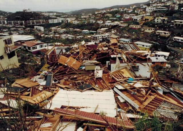
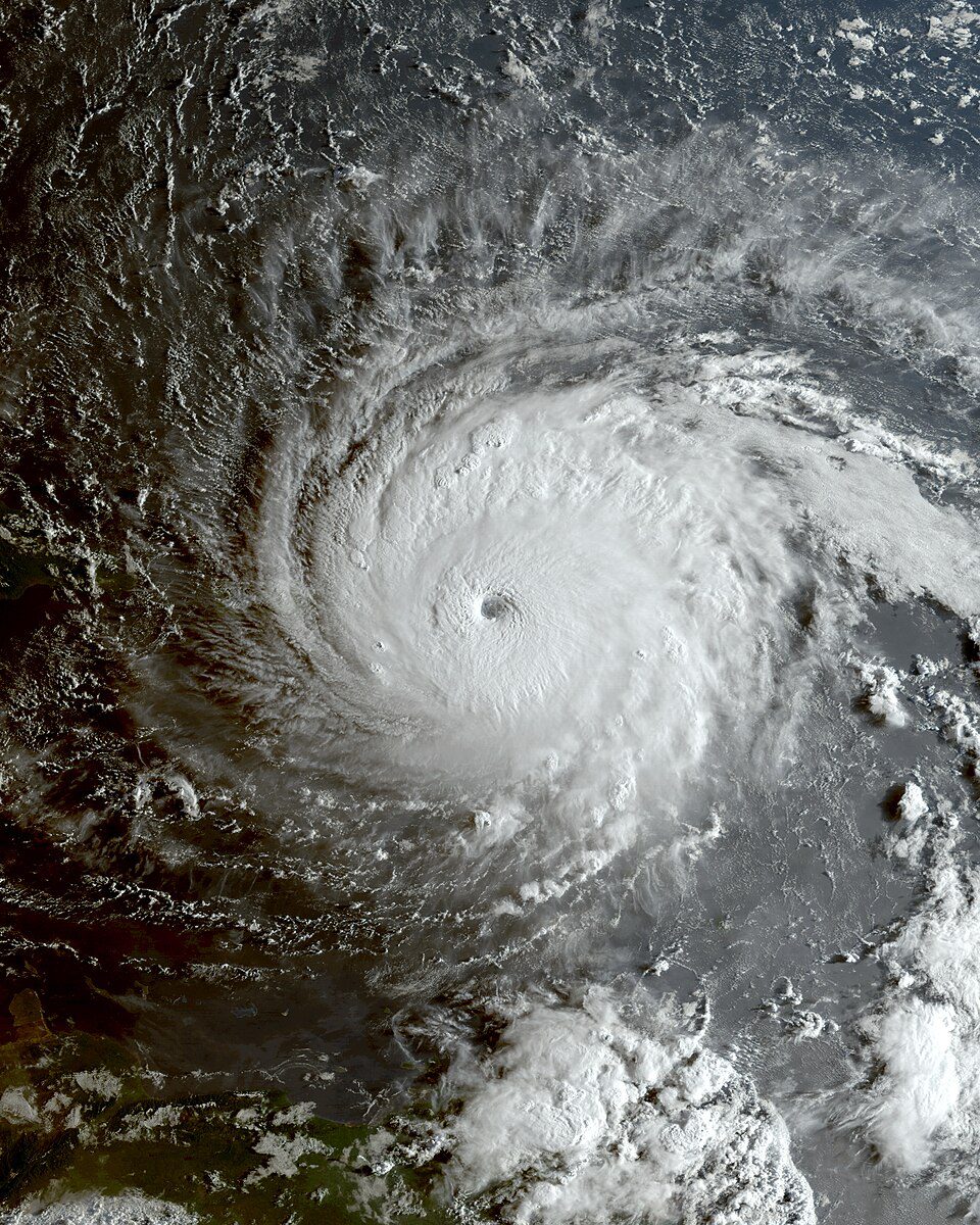
According to official records from the National Hurricane Center, Hurricane Marilyn struck the U.S. Virgin Islands between Sept. 15 and 16, 1995. The agency reported that the cyclone was a high-end Category 2 hurricane, nearly a Category 3 storm, at the time the hurricane hit the territory.

“Marilyn’s eye passed across the east end of St. Croix, where an amateur radio operator reported an unconfirmed wind gust of 127 mph around 5 p.m. AST Friday, Sept. 15, 1995,” according to a report from the NHC. “The eye then passed between St. Thomas and Culebra with the most devastating portion of the eyewall moving across the west part of St. Thomas. Here, both storm surge and wind caused widespread destruction. The Automated Surface Observing System, located at the St. Thomas airport, recorded sustained winds of 104 mph with a maximum gust to 129 mph around midnight, Sept. 15-16. These are the strongest recorded winds associated with Marilyn,” the NHC report explained.
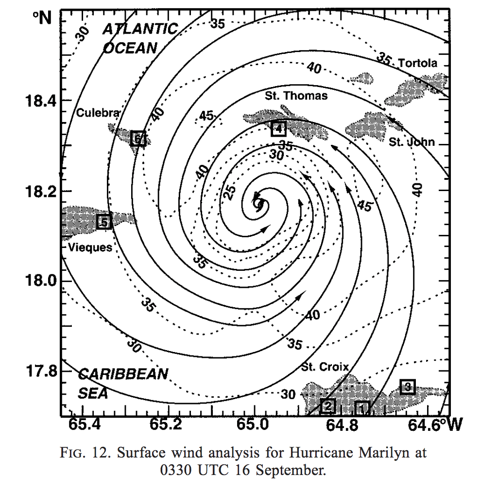
“Wind gusts approaching 140 mph were estimated from an aerial damage survey conducted soon after the hurricane’s passage. Heavy rains, mudslides, and strong winds pounded Culebra and Vieques, where damage was also considerable. Marilyn did not severely impact the main island of Puerto Rico, although some strong winds and heavy rains did affect the island,” according to the report.
The Source spoke with three experts from the National Hurricane Center, the National Oceanic and Atmospheric Administration, and the Virgin Islands Territorial Emergency Management Agency regarding advancements made to hurricane forecasting and preparation in the years since these storms. The individuals – NHC Warning Coordination Meteorologist Robbie Berg, NOAA Hurricane Hunter Sim Aberson, and VITEMA Director Daryl Jaschen – provided insight into how far we have come.
National Hurricane Center: Robbie Berg, NHC Warning Coordination Meteorologist
One of the major advancements regarding hurricane preparedness involves the additional amount of time that forecasts are issued to the public.
“Back in 1995, the NHC only made tropical cyclone track and intensity forecasts for the three days into the future,” according to Robbie Berg, warning coordination meteorologist with the NHC. “One of the biggest advancements since the mid-1990s is that NHC extended those forecasts out to five days beginning in 2001,” Berg said.
“In the 1990s, NHC’s three-day track forecasts had an average error of about 265 miles. Our three-day track errors for the current decade have been cut to an average of about 90 miles, a reduction of about 65%. Even our five-day track forecasts currently have an average error of about 200 miles, which is also less than the three-day forecasts from 1995,” Berg explained.
“NHC’s three-day intensity forecasts were off by an average of 20 mph in 1995, and those errors have been cut to 10–15 mph in the current decade,” he added.
Berg went on to note that forecasting the rapid intensification of hurricanes – when a storm’s winds increase sharply in a short period – remains challenging, though the center has made gains.
“Through a mixture of better tools, more accurate modeling, and forecaster experience, there are promising signs that NHC is getting better at detecting and predicting rapid intensification. In the years from 2010 to 2014, NHC’s 24-hour forecasts for rapidly intensifying storms were on average about 30 mph too low, and the storms strengthened 30 mph more than we were forecasting,” said Berg. “However, from 2020 to 2024, NHC’s 24-hour rapid intensification forecasts were 18 mph too low, so there is overall improvement. That said, there are still cases of unexpected rapid intensification, such as the case of Hurricane Otis, which hit Acapulco, Mexico, in 2023 as a Category 5 hurricane.”
Better Technology Improves Forecasts
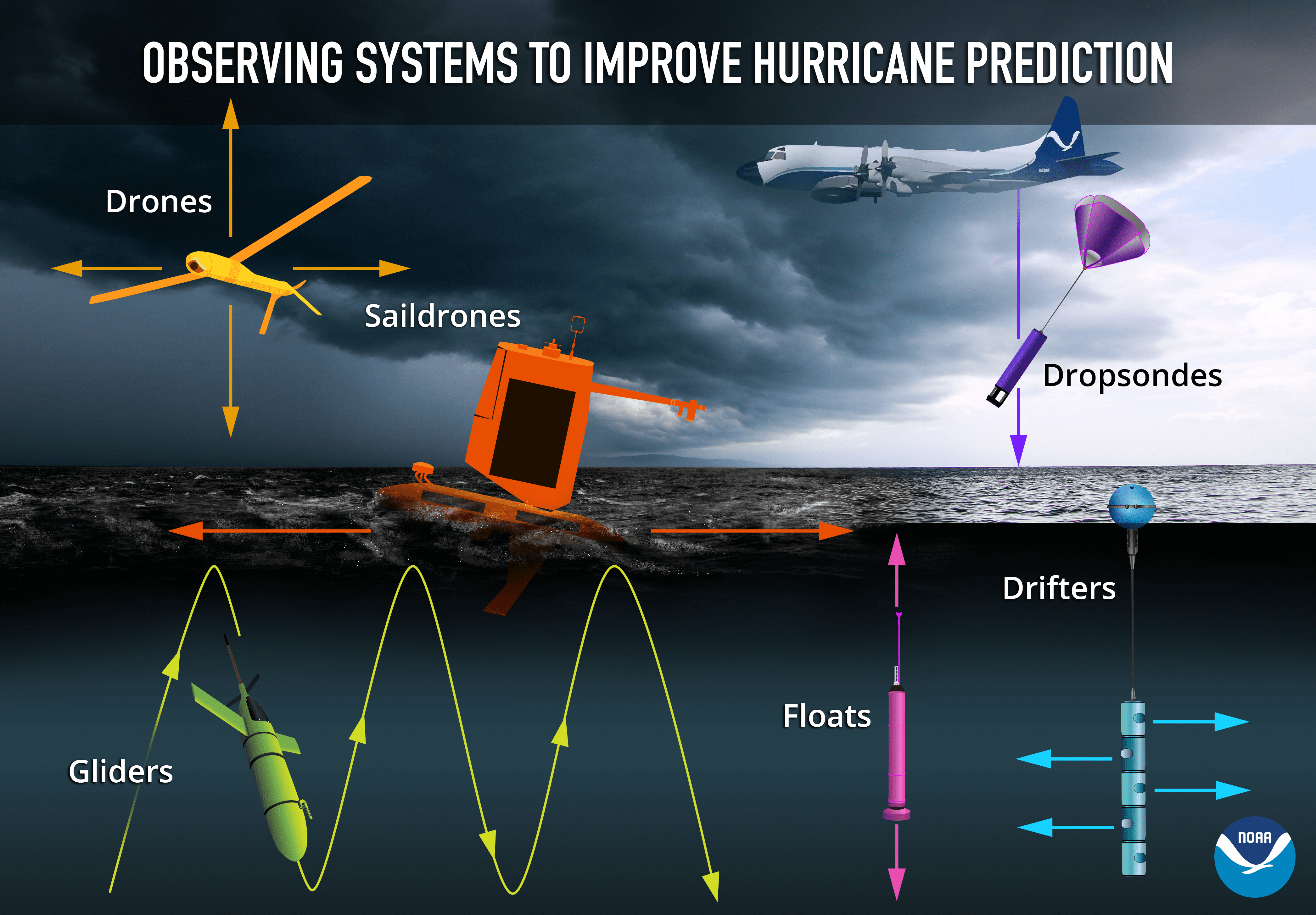
“Satellite technologies have improved over the past two decades, with the data now being available more frequently and at a higher resolution that helps us monitor storm trends,” he said. “New tools have been installed on Hurricane Hunter aircraft, including Tail Doppler Radar on the NOAA P-3 aircraft. This radar data helps give a more accurate three-dimensional view of the structure of the hurricane, which is also plugged into the computer models to help provide a more accurate simulation. Computing power has also increased exponentially over the past two decades, which has led to higher-resolution modeling of storms,” Berg explained.
Communication methods have also tremendously evolved over the years.
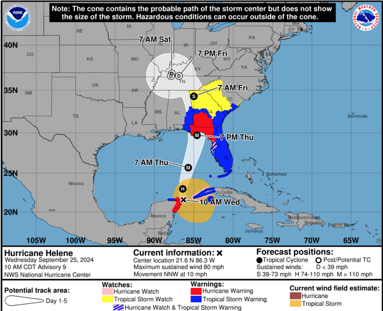
“Some of the biggest changes since the mid-1990s are the ways that we communicate the forecasts of hurricanes. We incorporate the uncertainty in our forecasts in the forecast graphics we produce, Berg stated. “For example, the cone of uncertainty began in 2002 to show that the center of a storm may not follow the exact forecast track. We’ve also unveiled several products that communicate the hazards that a storm could bring, including wind speed probabilities, time of wind arrival, when conditions could deteriorate, and potential storm surge flooding graphics.”
Hurricane Anxiety
When asked about advice for residents in the USVI and Puerto Rico who lived through hurricanes like Marilyn, Irma, or Maria – and who may feel anxious as each new season approaches – Berg offered the following insight.
“Anxiety and stress about hurricanes are perfectly normal – a lot has to be done to get ready for these storms, and life can be impacted significantly by the storm’s hazards,” Berg acknowledged. “However, preparation and having a plan definitely help to reduce that stress and anxiety. Making some preparations early, like putting your emergency supply kit together and not waiting until you’re under an actual threat, means that’s one less thing that’s on your plate. Do what you can now so that you’re not overwhelmed when a storm threatens.”
NOAA Hurricane Hunters: Sim Aberson
Sim Aberson, a NOAA meteorologist and Hurricane Hunter, told the Source that major strides have been made in hurricane forecasting since Hurricane Marilyn, especially in the assimilation of data gathered during aircraft reconnaissance.
“A huge amount has changed since 1995,” Aberson affirmed. “NOAA uses the same large aircraft now as in 1995 – the two P-3s – but with vastly improved technology. The Gulfstream-IV became available the next year and was used for tropical cyclones for the first time in 1997. The Air Force C130H planes, which were in use then, were retired about 2004 and replaced with C130Js,” he said.
Technology Improvements
One of the most important advances has been the use of instruments called dropwindsondes, which help Hurricane Hunters collect data while flying into a cyclone to investigate the storm.
“We now have dropwindsondes, which came online in 1997 and can reliably measure wind, temperature, and humidity in hurricanes,” Aberson said. “In 1995, by contrast, Doppler radars aboard the P-3s only had one antenna that scanned vertically. To get an analysis of the winds, you had to fly two aircraft perpendicular to each other through the storm at the same time, then manually quality control and combine the data. Combining this data took six months to a year for each pass through the hurricane, so we didn’t do it for many cases,” he explained.
“Now those radars have two antennas that scan fore and aft, providing the two looks needed for a complete wind analysis from one radar system,” Aberson said. “More importantly, we now quality-control the data and make the analyses in real time on the aircraft. We transmit the data to the NHC so they can see the system’s structure, and around the world to be assimilated into forecast models in real time. There has been amazing progress,” Aberson declared.
Data Collection Efficiency
Operational efficiency has also improved. “Because data collection and storage were so different back then, we used to have much larger crews. Now we can do a lot of the work on the ground, which saves a lot of time, effort, and money for the government while providing much better data,” he said.
“Overall, we’ve seen huge changes in observations, data assimilation, and model systems in 30 years,” Aberson added.
VITEMA: Director Daryl Jaschen
Daryl Jaschen, director of the Virgin Islands Territorial Emergency Management Agency since 2019, has witnessed significant changes in preparedness across the territory during his tenure.
“I’ve been in the territory, living on St. Croix, for a little over 20 years now,” he said. After retiring from the Virgin Islands National Guard in 2016, Jaschen was invited by Governor Bryan to serve as VITEMA director in 2019. “So that’s my seventh year as a director for VITEMA, and we’ve seen a lot of positive changes,” Jaschen said.
Jaschen highlighted the most important areas of progress, particularly since the passing of Hurricanes Irma and Maria in 2017, storms that many Virgin Islanders recall in vivid detail.
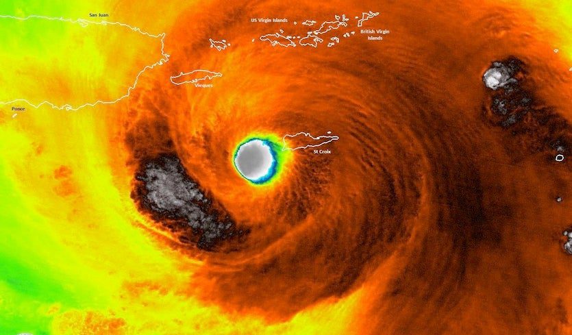
“In September 2017, Hurricanes Irma and Maria, two back-to-back Category 5 hurricanes, significantly impacted the U.S. Virgin Islands,” according to a report from the Federal Emergency Management Agency. “Hurricane Irma was the ninth named storm of the 2017 hurricane season when it impacted the USVI on September 6, and it devastated much of St. Thomas and St. John,” FEMA said.
“Two weeks later, on September 20, Hurricane Maria passed directly by St. Croix and devastated the previously damaged USVI. Homes, schools, hospitals, infrastructure, and public services, particularly in St. Croix, were significantly impacted by this second storm. Hurricane Maria also caused further complications to the Hurricane Irma response, as emergency workers and residents dealt with multiple events and interruptions to the effort. The storms placed additional pressure on an already strained economy, which relies heavily on tourism and a thriving hospitality industry,” the FEMA report explained.
“Hurricanes Irma and Maria were the strongest hurricanes to strike the USVI since Hurricane Marilyn in 1995,” FEMA noted.
Speaking to the advancements made since the devastating hurricanes of the past, Jaschen noted that several areas stand out, and he shared details in a comprehensive interview with the Source.
Communications
“We’ve become much more reliant upon our smartphones to do everything for us. And, of course, that ties us into having connectivity to cell towers as well as the internet for doing many things. We’ve seen technology improve tremendously for us as individuals, for businesses, as well as for first responders and emergency responders,” Jaschen said.
Jaschen explained that a major part of this connectivity advancement has been a new 911 system across the territory.
“We’ve put in a new 911 system that gives us the ability to see on a map where they’re calling from and have much better information provided to us,” Jaschen explained. He pointed out that this system can significantly improve the capability to dispatch fire, police, and emergency medical services to the community.
Jaschen also highlighted new options for staying connected during storms, noting that communication lines are increasingly being placed underground for greater reliability, while satellite systems provide backup when traditional infrastructure fails. He added that newer technology now allows text messages to be sent via satellite if mobile towers are down, ensuring people still have a way to communicate even without standard service.
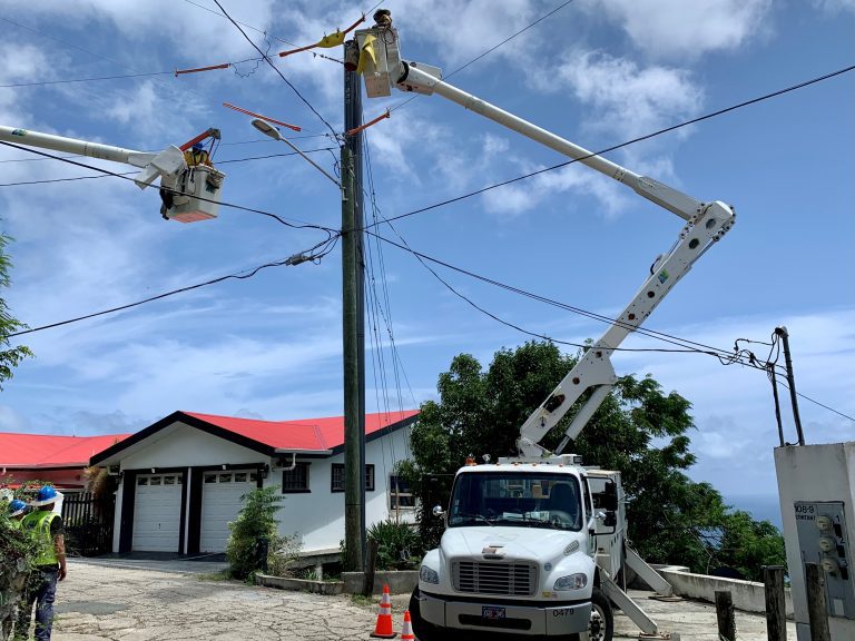
Power Grid
Power resilience is another key area. While acknowledging that improvements need to continue with the power grid across the territory, he pointed to newer energy solutions such as solar power increasing across households and businesses in the USVI. “We’ve seen the electrical technology improve tremendously to provide solar power for homes, for businesses, and battery backup systems for added support,” he said.
Jaschen added that underground power lines and newer composite poles that have been installed since Hurricanes Irma and Maria are helping strengthen the grid.
“We now are pursuing underground power, which is great for us to keep that reliance up. We have several thousand composite poles within St. Thomas, St. Croix, St. John and Water Island,” Jaschen said. “They’re hollow poles, but from a wind perspective, they can definitely stand up to the wind.”
Still, vulnerabilities remain, Jaschen admitted, especially when falling trees damage power lines. He emphasized that keeping trees and brush trimmed during hurricane season can help reduce the risk.
Evacuations
Jaschen recalled that evacuating patients during the 2017 storms was difficult, when people moved from the territory to Puerto Rico and then relocated again after Maria, often without proper tracking. Since then, he said, there have been major improvements.
The territory now has a strong patient movement evacuation plan coordinated by the Department of Health and local hospitals, Jaschen noted. A key part of that plan is J-PATS, the Joint Patient Assessment and Tracking System, which electronically monitors individuals from the time they leave the territory under a disaster declaration until they reach their destination.
Seniors Safety
Jaschen said the Senior Registry has also been an important step. It allows residents over 60 who live alone, or anyone with a disability living alone regardless of age, to sign up and request a health and welfare check after a storm. Jaschen explained that forms are available at BMV Offices and Elections Offices.
FEMA
On FEMA readiness, Jaschen said there are now warehouses on St. Croix and St. Thomas, along with containers on St. John, stocked with supplies. These include boxed water with a 10-year shelf life that can be distributed quickly after a storm, as well as shelf-stable meals. He emphasized that having about a 10-day supply on-island marks a major improvement compared to 2017.
“We have about 10 days of supply of that water and shelf-stable meals. The fact we have that 10-day supply is such a great improvement from what we had in 2017.”
Continued Progress Needed
Despite the progress, Jaschen was clear-eyed about challenges, including the continued need to ensure that the hospitals across the territory are able to withstand future disasters.
“Our biggest vulnerabilities right now are our two hospitals,” Jaschen noted.
Even with limitations, Jaschen believes the territory is in a stronger position than before. When asked if he feels the USVI is safer and better prepared today, he said, “I would say yes. Having gone through past storms, people take the forecasts more seriously now. And with five to six days’ advance notice, that time is very, very important.”
He added that individual preparedness has also improved. Stronger communications and power systems put residents, families, and businesses in a better position, and building code changes have resulted in sturdier structures.
Finally, he urged self-reliance. “We now understand what it means when I say be self-sufficient for five to 10 days. You need to be on your own.”
A Local Perspective
Additionally, the Source connected with Rafe Boulon, a weather observer on St. John, who meticulously records rainfall data from his home at Trunk Bay. Boulon, who has spent his life living in the USVI, shared thoughts on what he believes has significantly improved across the territory regarding hurricane readiness. Notably, Boulon affirmed many of the improvements that have been shared in this story, and he feels more confident that the islands are in a better position to withstand a disaster than in previous years.
Boulon noted he was not in the territory when Hurricane Luis or Hurricane Marilyn struck the USVI. However, he’s been on island for every other storm in recent history.
“Hurricanes Luis and Marilyn were the only two cyclones where I was not in the Caribbean – in either the Virgin Islands or on Puerto Rico – in the last 70+ years,” Boulon said. “There have been a number of changes that have made a difference in storms, including since Hurricane Hugo in 1989.”
“For example, WAPA has made upgrades that have reduced time without electricity,” Boulon explained. “We were without power for four months after Hugo, three months after Marilyn, two months after Irma and only 10 hours after the recent brush with Hurricane Erin, admittedly a much lower impact storm,” Boulon noted.
“Upgrades include the installation of new, stronger electric poles and more frequent vegetation clearing along power line easements. Changes to the building codes have also reduced much of the damage to structures that we saw with some of the earlier storms,” he noted.
“Additionally, VITEMA has become more proactive with notifications and suggestions for preparations for storm events,” Boulon stated.
“In general, I think the Virgin Islands population is more aware and better prepared as a result of past storms. People take them more seriously and work together to help each other, both before and after storms,” Boulon concluded.

