Sargassum remained at very high levels across the Atlantic basin during June, with the seaweed continuing to affect coastlines across the region. The latest outlook from the University of South Florida’s Optical Oceanography Lab suggests more shoreline impacts are possible in the weeks ahead.
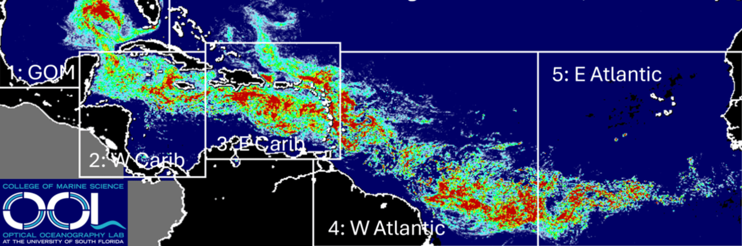
The Optical Oceanography Lab at USF monitors the presence of sargassum across the Atlantic, Caribbean, and Gulf regions using satellite imagery. In its June 30 bulletin, USF reported that the seaweed continued to increase in most monitored areas during June, while the Caribbean Sea remained at record-high levels for the month.
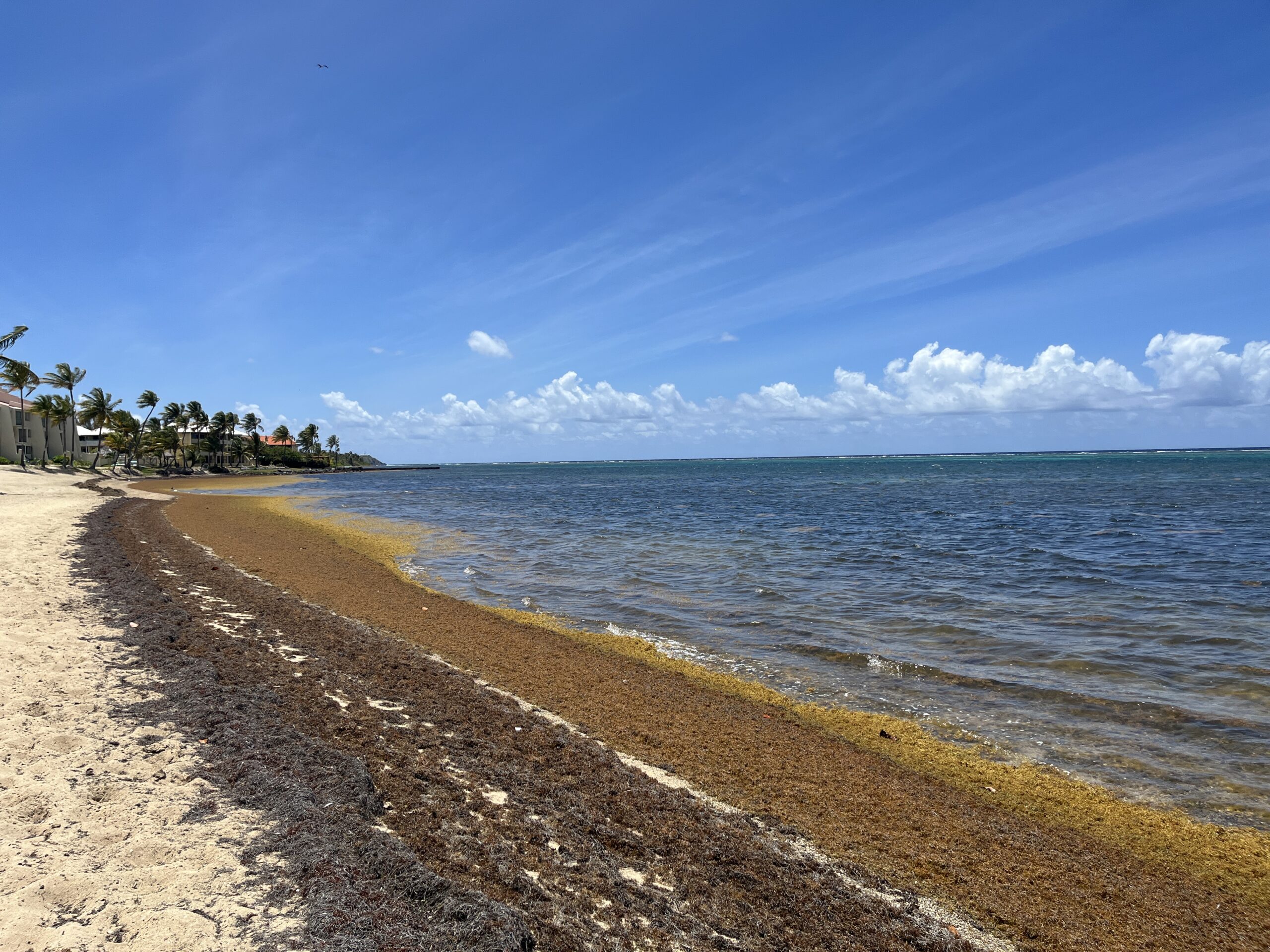
“As predicted in May, total sargassum amount in all but the East Atlantic region continued to increase in June, while the distribution patterns remained stable,” the USF report said. “The Caribbean Sea continued to show record-high sargassum amount for the month of June, and the total sargassum amount in the Gulf reached 5 million metric tons, which nearly doubled the historical record in 2025. As a result, severe beaching events have been reported along the southeast coast of Florida. Likewise, beaching events have also continued around the Caribbean and Lesser Antilles islands,” USF continued.
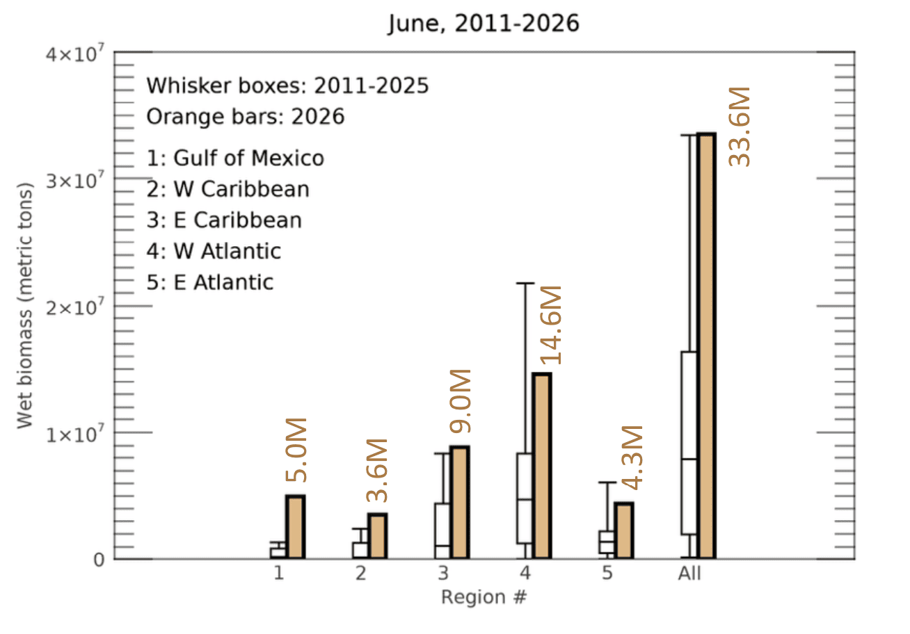
The bulletin included a chart that depicted an estimated 33.6 million metric tons of sargassum across all monitored regions during June, compared to historical values for the month of June between the years 2011 and 2026.
For June 2026, the chart showed 9 million metric tons in the eastern Caribbean — the region nearest to the Virgin Islands — and 14.6 million metric tons in the Western Atlantic. The Gulf region reached 5 million metric tons, while the Western Caribbean was listed at 3.6 million metric tons. The eastern Atlantic was listed at 4.3 million metric tons.
Local Sargassum Effects
For the U.S. Virgin Islands and Puerto Rico, impacts from the seaweed will continue to depend on winds, currents, tides, swell direction, and nearshore conditions. Even when the broader region is active, conditions can change quickly from one beach to another and from one day to the next.
Because both U.S. territories sit within the eastern Caribbean and Lesser Antilles region, additional arrivals of the seaweed remain possible in the weeks ahead. Residents and visitors are encouraged to monitor local beach conditions, particularly during periods of changing winds or currents.
USF said amounts are expected to fluctuate in July and may not rise as sharply, but beaching events are still expected to continue.
“Sargassum amount in most regions is likely to change slightly, either increase or decrease, in July,” USF predicted.
The lab added that shoreline impacts are also expected to remain a concern.
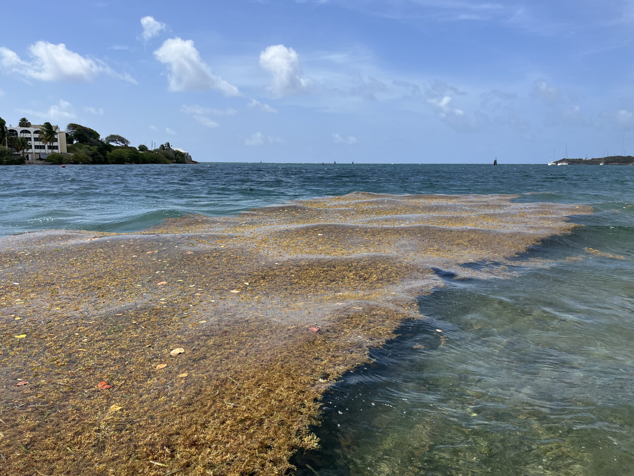
“Beaching events around the Caribbean and southeast coast of Florida will continue and likely increase. Some beaching events may also occur around Florida’s Panhandle region. The year of 2026 is set to be at least the second largest sargassum year, as the total amount in June is only 10% lower than the historical record in 2025,” according to the USF bulletin.
Sargassum Explained
As the Source previously reported, sargassum seaweed plays an important role offshore as habitat for marine life, but it can also create problems when winds and currents carry large mats ashore, according to the National Oceanic and Atmospheric Administration.
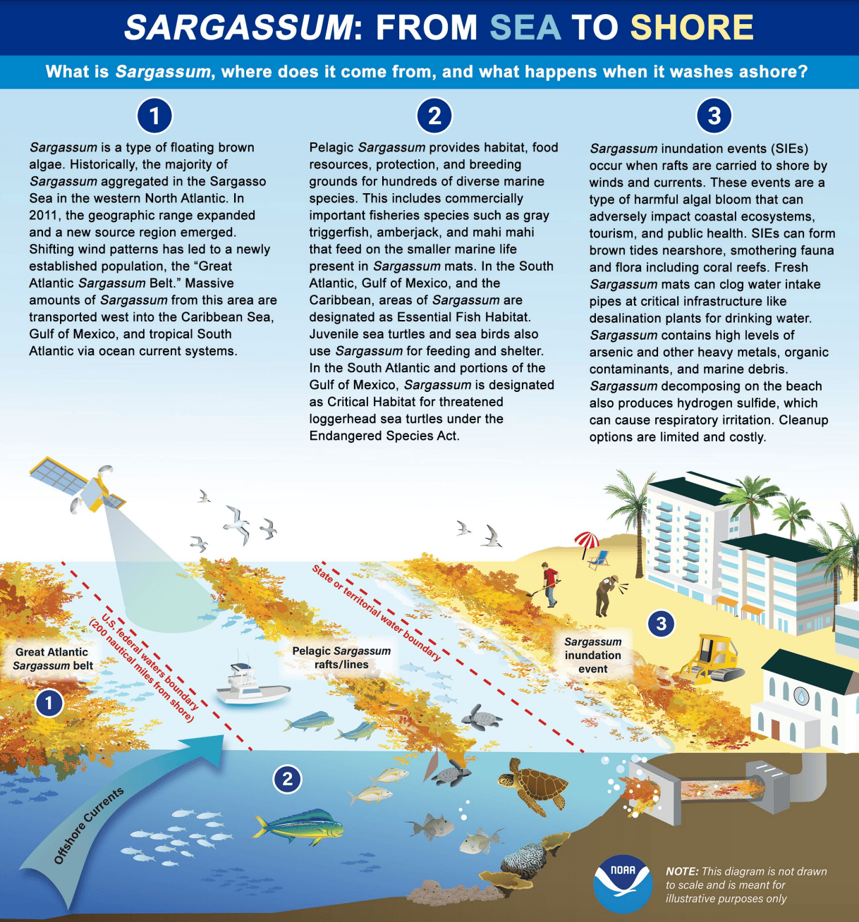
“Sargassum is a type of floating brown algae that provides food, protection, and habitat for many marine species. While sargassum plays an important role in the health and biodiversity of open ocean ecosystems, it can also be harmful in certain situations, when rafts of this brown algae are carried to shore by winds and currents,” NOAA said.
Efforts to help contain beaching events along the USVI were reported in a previous Source interview with Amy Dempsey, a marine biologist and founder of the consulting firm Bioimpact, Inc. Officials in the territory have begun using floating barriers to divert incoming mats of sargassum before they reach the shoreline. The booms have shown promise in keeping beaches clearer, but they require constant upkeep due to strong currents and storm damage and must be removed ahead of approaching cyclones.
Monitoring Local Conditions
Individuals can follow the progression of the current algae bloom through USF’s Sargassum Watch System. Previous monthly bulletins and daily imagery are available through the system, while high-resolution maps for selected coastal regions are also available through USF’s Optical Oceanography Lab satellite data products.
Residents and visitors across the U.S. Virgin Islands are also encouraged to follow local weather and marine forecasts, since winds, currents and sea conditions can influence where and when sargassum reaches the shoreline. Weather information is available from the National Weather Service, in San Juan, Puerto Rico, the National Oceanic and Atmospheric Administration, and the Source Weather Page.

