


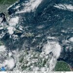
A strong tropical wave is forecast to pass through the Caribbean early this week, beginning around Monday, bringing the potential for heavy rain and gusty winds to the region. The National Hurricane Center (NHC) is closely watching several tropical waves, including one located near the Lesser Antilles island chain, designated as “Invest 90L.” (An “invest” is an area under investigation for tropical development by the NHC.)
As of an update from the NHC on Saturday afternoon, the tropical wave has a moderate chance of experiencing additional organization before impacting the area, including the USVI and Puerto Rico.
“A broad area of low pressure has formed near the Windward Islands, [and] shower and thunderstorm activity has become better organized since yesterday,” according to the NHC update.
“Some additional development of this system is likely, and a tropical depression could form by early next week while this system moves westward to west-northwestward at 10 to 15 mph, across the Lesser Antilles and over the eastern and central Caribbean Sea,” the update continued.
Preparing for Impacts
Even if this system does not develop further, impacts are expected to be felt across the islands.
A message from the National Weather Service (NWS) in San Juan, PR, on Saturday morning mentioned some of the possible effects of the storm system.
“Regardless of development, unsettled weather conditions are expected between Monday into early Wednesday,” according to the NWS. “The resulting rains from the expected enhanced showers and isolated to scattered thunderstorms could result in flooding impacts and mudslides in areas of steep terrain. Breezy conditions and thunderstorm activity may also result in deteriorating marine and surf zone conditions.”
Stay Updated on the Weather
Apart from the aforementioned tropical wave, the NHC is monitoring several other areas of potential tropical development, including “Tropical Depression Six,” a newly formed tropical depression. Updates will be posted to the Source Weather Page as they become available.
USVI visitors and residents can also find information about severe weather, including emergency shelters and alerts, from the Virgin Islands Territorial Emergency Management Agency and the National Weather Service website.