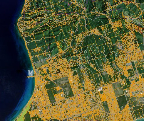
Anyone with an Internet connection can now see the latest precision geospatial information system (GIS) images of U.S. Virgin Islands estates and individual land parcels through the website of the Office of the Lieutenant Governor, according to Government House.
GIS software allows digital mapping information to be selected and layered, adding or subtracting information, anchoring the data to known map points established by satellite data. In this way, "cadastral" maps showing property lines, maps of utility lines, 911 addresses and directions, topographical, environmental or archeological data can all be tied together, to varying degrees, in a single, highly accurate relational database. It can be used to map out all manner of information, adding or subtracting layers to highlight what the viewer is interested in.
Because it ties the data to known, highly accurate location points through GPS, it can vastly improve the accuracy of all kinds of mapping and help make many services, from emergency response to utility repair, faster, easier and more efficient.
The V.I. Geospatial Information Council, a group of private- and public-sector representatives, first assembled in 2005 to promote the study and implementation of the GIS. The GIS project was launched under the supervision of former Lt. Gov. Vargrave Richards, who also sought to use the network to connect the many smaller entities included under the umbrella of the lieutenant governor’s office. Lt. Gov. Gregory Francis has continued to broaden the system
The online viewer was developed as part of the Geospatial Strategic Planning Project, which seeks to set up a system to make the new, digital data more readily accessible to the community and local and federal GIS partners. The GIS maps that can be viewed online present an aerial view of the territory’s topography, making it possible to see the shapes of properties and roads in the area. The maps are also searchable by parcel number and estate.
The viewer shows the potential of web-based access to the territory’s spatial data assets, including parcels, elevation, and aerial photography.
“GIS data has proven useful to the public and private sectors as a tool for infrastructure planning and community development,” said Francis in a Government House statement. “Access to this information can be an asset to all residents,” he said, “particularly as we continue to seek their involvement in the street naming and addressing project, which would enhance public safety by making it easier for emergency responders to find locations.”
The GIS viewer can be accessed via Francis’ office. At this time, the viewer is still in development and is for demonstration purposes only.


